Framed Print > Arts > Landscape paintings > Waterfall and river artworks > River artworks
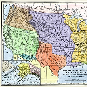
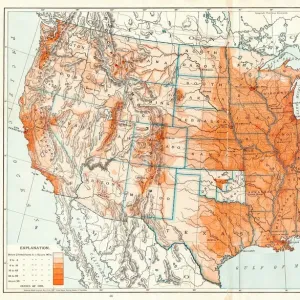
Framed Print : MAP: UNITED STATES, 1820. Engraved map of the United States, 1820, drawing on the geographical discoveries of the Lewis


![]()
Framed Photos from Granger
MAP: UNITED STATES, 1820. Engraved map of the United States, 1820, drawing on the geographical discoveries of the Lewis
MAP: UNITED STATES, 1820. Engraved map of the United States, 1820, drawing on the geographical discoveries of the Lewis & Clark expedition
Granger holds millions of images spanning more than 25,000 years of world history, from before the Stone Age to the dawn of the Space Age
Media ID 6617689
1820 Louisiana Purchase Territory Westward Expansion
18"x14" Modern Frame
Discover history with our exquisite Framed Prints from Media Storehouse. This captivating piece features an engraved map of the United States from 1820, showcasing the geographical discoveries of the renowned Lewis & Clark expedition. The Granger Collection's "MAP: UNITED STATES, 1820" brings the rich history of early American exploration to life. Each print is meticulously framed to preserve and enhance the intricate details of the map, making it a stunning addition to any home or office. Travel back in time and adorn your space with a piece of historical significance.
16x12 Print in an MDF Wooden Frame with 180 gsm Satin Finish Paper. Glazed using shatter proof thin plexiglass. Frame thickness is 1 inch and depth 0.75 inch. Fluted cardboard backing held with clips. Supplied ready to hang with sawtooth hanger and rubber bumpers. Spot clean with a damp cloth. Packaged foam wrapped in a card.
Contemporary Framed and Mounted Prints - Professionally Made and Ready to Hang
Estimated Image Size (if not cropped) is 40.6cm x 35.6cm (16" x 14")
Estimated Product Size is 45.7cm x 35.6cm (18" x 14")
These are individually made so all sizes are approximate
Artwork printed orientated as per the preview above, with landscape (horizontal) orientation to match the source image.
FEATURES IN THESE COLLECTIONS
> Arts
> Landscape paintings
> Waterfall and river artworks
> River artworks
> Maps and Charts
> Early Maps
> Maps and Charts
> Related Images
> Granger Art on Demand
> Maps
EDITORS COMMENTS
This print showcases an engraved map of the United States from the year 1820, meticulously drawing on the geographical discoveries made during the renowned Lewis & Clark expedition. The map beautifully captures a pivotal moment in American history, as it reflects both the late stages of westward expansion and the early development of this great nation. The intricate details depicted on this map highlight various territories and rivers that played significant roles in shaping America's destiny. It serves as a visual testament to the vastness and diversity of this young country at that time. One cannot help but be mesmerized by its artistry, which expertly combines accuracy with artistic flair. Of particular note is how this map represents one of America's most monumental acquisitions – the Louisiana Purchase. This historic event doubled the size of our nation overnight and opened up new opportunities for exploration, settlement, and trade. As we gaze upon this remarkable piece from The Granger Collection, we are transported back to a time when America was still forging its identity amidst untamed wildernesses and uncharted territories. It reminds us not only of our rich history but also inspires us to appreciate those who fearlessly ventured into unknown lands to shape our present reality. Whether you are an avid historian or simply captivated by artistry, this print is sure to ignite your imagination and spark conversations about America's past achievements while serving as a reminder that there is always more to discover within ourselves and beyond our borders.
MADE IN THE USA
Safe Shipping with 30 Day Money Back Guarantee
FREE PERSONALISATION*
We are proud to offer a range of customisation features including Personalised Captions, Color Filters and Picture Zoom Tools
SECURE PAYMENTS
We happily accept a wide range of payment options so you can pay for the things you need in the way that is most convenient for you
* Options may vary by product and licensing agreement. Zoomed Pictures can be adjusted in the Cart.