Metal Print > Arts > Art Movements > Renaissance Art
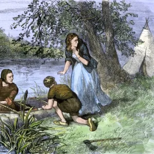
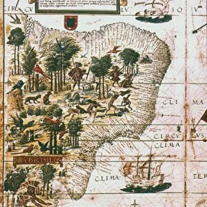
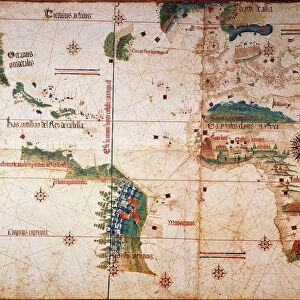
Metal Print : BRAZIL: MAP AND NATIVE INDIANS. Portuguese map of Brazil, 1565, depicting a family of native Indians, one of whom is harvesting brazilwood trees (probably Caesalpinia echinata


![]()
Metal Prints from Granger
BRAZIL: MAP AND NATIVE INDIANS. Portuguese map of Brazil, 1565, depicting a family of native Indians, one of whom is harvesting brazilwood trees (probably Caesalpinia echinata
BRAZIL: MAP AND NATIVE INDIANS. Portuguese map of Brazil, 1565, depicting a family of native Indians, one of whom is harvesting brazilwood trees (probably Caesalpinia echinata or Sappan)
Granger holds millions of images spanning more than 25,000 years of world history, from before the Stone Age to the dawn of the Space Age
Media ID 6622151
1565 Age Of Discovery American Indian Brazil Brazilian New World Portolan Chart Portuguese
16"x20" (51x41cm) Metal Print
Discover the rich history of Brazil with our stunning Metal Print of a 1565 Portuguese map. This captivating piece showcases not only the early exploration of the land, but also highlights the native Indians and their traditional way of life. One native is depicted harvesting brazilwood trees, adding a vibrant touch to the map. Bring a piece of history into your home or office with the high-quality and durable finish of our Metal Prints. The intricate details of the map and the vivid colors of the natives are sure to impress.
Made with durable metal and luxurious printing techniques, our metal photo prints go beyond traditional canvases, adding a cool, modern touch to your space. Wall mount on back. Eco-friendly 100% post-consumer recycled ChromaLuxe aluminum surface. The thickness of the print is 0.045". Featuring a Scratch-resistant surface and Rounded corners. Backing hangers are attached to the back of the print and float the print 1/2-inch off the wall when hung, the choice of hanger may vary depending on size and International orders will come with Float Mount hangers only. Finished with a brilliant white high gloss surface for unsurpassed detail and vibrance. Printed using Dye-Sublimation and for best care we recommend a non-ammonia glass cleaner, water, or isopropyl (rubbing) alcohol to prevent harming the print surface. We recommend using a clean, lint-free cloth to wipe off the print. The ultra-hard surface is scratch-resistant, waterproof and weatherproof. Avoid direct sunlight exposure.
Made with durable metal and luxurious printing techniques, metal prints bring images to life and add a modern touch to any space
Estimated Image Size (if not cropped) is 40.6cm x 50.8cm (16" x 20")
Estimated Product Size is 41.2cm x 51.4cm (16.2" x 20.2")
These are individually made so all sizes are approximate
Artwork printed orientated as per the preview above, with portrait (vertical) orientation to match the source image.
FEATURES IN THESE COLLECTIONS
> Granger Art on Demand
> Maps
> Arts
> Art Movements
> Renaissance Art
> Arts
> Landscape paintings
> Waterfall and river artworks
> River artworks
> Europe
> Portugal
> Related Images
> Maps and Charts
> Related Images
EDITORS COMMENTS
This print takes us back to the year 1565, offering a glimpse into the rich history of Brazil. The Portuguese map of Brazil beautifully illustrates the vastness and diversity of this South American country during the Renaissance period. As we delve deeper into this intricate artwork, our attention is drawn to a family of native Indians depicted within its borders. Intriguingly, one member of this indigenous family can be seen engaged in the meticulous process of harvesting brazilwood trees. These trees, most likely Caesalpinia echinata or Sappan species, hold great significance in Brazilian history as they were highly valued for their vibrant red dye known as "brazilin". This valuable resource played a crucial role in trade and commerce during that era. The map itself serves as both an informative tool and a work of art from the Age of Discovery. It showcases not only geographical features such as rivers but also provides insights into American Indian settlements across Brazil's vast landscape. As we explore this remarkable piece from The Granger Collection's archives, it invites us to reflect on Brazil's cultural heritage and its deep connection with nature. It reminds us that beyond being just lines on paper, maps have always been windows through which we can discover fascinating stories about our world and its diverse inhabitants.
MADE IN THE USA
Safe Shipping with 30 Day Money Back Guarantee
FREE PERSONALISATION*
We are proud to offer a range of customisation features including Personalised Captions, Color Filters and Picture Zoom Tools
SECURE PAYMENTS
We happily accept a wide range of payment options so you can pay for the things you need in the way that is most convenient for you
* Options may vary by product and licensing agreement. Zoomed Pictures can be adjusted in the Cart.
![Ouro Preto - [ World Heritage Site by UNESCO ]](/sq/629/ouro-preto-world-heritage-site-unesco-11983598.jpg.webp)