Fine Art Print > Arts > Art Movements > Renaissance Art
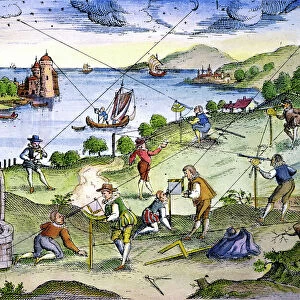
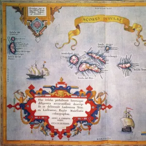
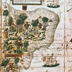
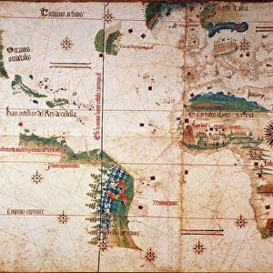
Fine Art Print : BRAZIL: MAP AND NATIVE INDIANS. Portuguese map of Brazil, 1565, depicting a family of native Indians, one of whom is harvesting brazilwood trees (probably Caesalpinia echinata


![]()
Fine Art Prints from Granger
BRAZIL: MAP AND NATIVE INDIANS. Portuguese map of Brazil, 1565, depicting a family of native Indians, one of whom is harvesting brazilwood trees (probably Caesalpinia echinata
BRAZIL: MAP AND NATIVE INDIANS. Portuguese map of Brazil, 1565, depicting a family of native Indians, one of whom is harvesting brazilwood trees (probably Caesalpinia echinata or Sappan)
Granger holds millions of images spanning more than 25,000 years of world history, from before the Stone Age to the dawn of the Space Age
Media ID 6622151
1565 Age Of Discovery American Indian Brazil Brazilian New World Portolan Chart Portuguese
20"x16" (+3" Border) Fine Art Print
Discover the rich history and culture of Brazil with our exquisite Fine Art Print of a 1565 Portuguese map. This captivating print showcases the early exploration of Brazil, featuring a detailed map of the region and a depiction of native Indians in their natural habitat. One native is shown harvesting brazilwood trees, a valuable resource for the Portuguese during this era. Add an authentic touch of history to your home or office with this beautifully detailed and intriguing piece from Media Storehouse's Fine Art Prints collection.
20x16 image printed on 26x22 Fine Art Rag Paper with 3" (76mm) white border. Our Fine Art Prints are printed on 300gsm 100% acid free, PH neutral paper with archival properties. This printing method is used by museums and art collections to exhibit photographs and art reproductions.
Our fine art prints are high-quality prints made using a paper called Photo Rag. This 100% cotton rag fibre paper is known for its exceptional image sharpness, rich colors, and high level of detail, making it a popular choice for professional photographers and artists. Photo rag paper is our clear recommendation for a fine art paper print. If you can afford to spend more on a higher quality paper, then Photo Rag is our clear recommendation for a fine art paper print.
Estimated Image Size (if not cropped) is 35.9cm x 50.8cm (14.1" x 20")
Estimated Product Size is 55.9cm x 66cm (22" x 26")
These are individually made so all sizes are approximate
Artwork printed orientated as per the preview above, with portrait (vertical) orientation to match the source image.
FEATURES IN THESE COLLECTIONS
> Arts
> Art Movements
> Renaissance Art
> Arts
> Landscape paintings
> Waterfall and river artworks
> River artworks
> Europe
> Portugal
> Related Images
> Maps and Charts
> Related Images
> Granger Art on Demand
> Maps
EDITORS COMMENTS
This print takes us back to the year 1565, offering a glimpse into the rich history of Brazil. The Portuguese map of Brazil beautifully illustrates the vastness and diversity of this South American country during the Renaissance period. As we delve deeper into this intricate artwork, our attention is drawn to a family of native Indians depicted within its borders. Intriguingly, one member of this indigenous family can be seen engaged in the meticulous process of harvesting brazilwood trees. These trees, most likely Caesalpinia echinata or Sappan species, hold great significance in Brazilian history as they were highly valued for their vibrant red dye known as "brazilin". This valuable resource played a crucial role in trade and commerce during that era. The map itself serves as both an informative tool and a work of art from the Age of Discovery. It showcases not only geographical features such as rivers but also provides insights into American Indian settlements across Brazil's vast landscape. As we explore this remarkable piece from The Granger Collection's archives, it invites us to reflect on Brazil's cultural heritage and its deep connection with nature. It reminds us that beyond being just lines on paper, maps have always been windows through which we can discover fascinating stories about our world and its diverse inhabitants.
MADE IN THE USA
Safe Shipping with 30 Day Money Back Guarantee
FREE PERSONALISATION*
We are proud to offer a range of customisation features including Personalised Captions, Color Filters and Picture Zoom Tools
SECURE PAYMENTS
We happily accept a wide range of payment options so you can pay for the things you need in the way that is most convenient for you
* Options may vary by product and licensing agreement. Zoomed Pictures can be adjusted in the Cart.
![Ouro Preto - [ World Heritage Site by UNESCO ]](/sq/629/ouro-preto-world-heritage-site-unesco-11983598.jpg.webp)