Metal Print > Europe > United Kingdom > England > Maps
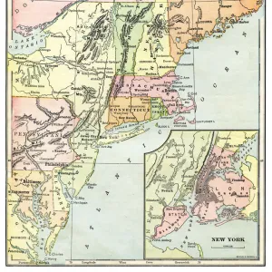
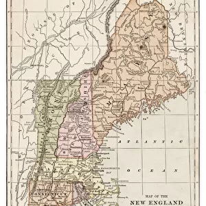
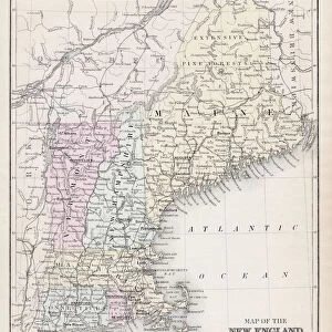
Metal Print : Map of New England states 1889


![]()
Metal Prints from Fine Art Storehouse
Map of New England states 1889
Comprehensive Geography by James Monteith - American Book Company 1882, 1889
Unleash your creativity and transform your space into a visual masterpiece!
THEPALMER
Media ID 18357287
16"x20" (51x41cm) Metal Print
Discover the historical charm of the New England region with our stunning Metal Print of the 1889 Map of New England States by THEPALMER from the Media Storehouse Fine Art Storehouse collection. Originally published in Comprehensive Geography by James Monteith from the American Book Company in 1882 and 1889, this vintage map showcases intricate detail and accurate cartography of the time. Bring a piece of American history into your home or office with this beautiful and durable Metal Print, meticulously crafted to bring out the rich colors and textures of the original illustration. Each print is individually printed and mounted on a lightweight, rust-resistant aluminum sheet for a sleek and modern look that is sure to impress. Order now and transport yourself back in time with this unique and captivating piece of art.
Made with durable metal and luxurious printing techniques, our metal photo prints go beyond traditional canvases, adding a cool, modern touch to your space. Wall mount on back. Eco-friendly 100% post-consumer recycled ChromaLuxe aluminum surface. The thickness of the print is 0.045". Featuring a Scratch-resistant surface and Rounded corners. Backing hangers are attached to the back of the print and float the print 1/2-inch off the wall when hung, the choice of hanger may vary depending on size and International orders will come with Float Mount hangers only. Finished with a brilliant white high gloss surface for unsurpassed detail and vibrance. Printed using Dye-Sublimation and for best care we recommend a non-ammonia glass cleaner, water, or isopropyl (rubbing) alcohol to prevent harming the print surface. We recommend using a clean, lint-free cloth to wipe off the print. The ultra-hard surface is scratch-resistant, waterproof and weatherproof. Avoid direct sunlight exposure.
Made with durable metal and luxurious printing techniques, metal prints bring images to life and add a modern touch to any space
Estimated Image Size (if not cropped) is 40.6cm x 50.8cm (16" x 20")
Estimated Product Size is 41.2cm x 51.4cm (16.2" x 20.2")
These are individually made so all sizes are approximate
Artwork printed orientated as per the preview above, with portrait (vertical) orientation to match the source image.
FEATURES IN THESE COLLECTIONS
> Fine Art Storehouse
> Map
> Historical Maps
> Europe
> United Kingdom
> England
> Maps
> Europe
> United Kingdom
> England
> Posters
> Europe
> United Kingdom
> England
> Related Images
> Maps and Charts
> Related Images
EDITORS COMMENTS
In this print titled "Map of New England states 1889" we are transported back in time to an era when cartography was both a science and an art form. The map, originally featured in James Monteith's renowned Comprehensive Geography book published by the American Book Company in 1882 and updated in 1889, offers us a glimpse into the geographical landscape of one of America's most historically significant regions. The intricate details and exquisite craftsmanship showcased on this vintage map are truly remarkable. From the delicate calligraphy labeling each state to the meticulously drawn boundaries, every element reflects the dedication and expertise that went into its creation. As we explore this piece, our eyes trace over rivers winding through lush forests, mountains majestically rising towards the sky, and cities bustling with life. Beyond its aesthetic appeal, this map holds immense historical value. It serves as a testament to how much New England has evolved over time while also preserving important landmarks from yesteryears. By studying it closely, one can gain insights into early settlements, transportation routes vital for trade and commerce during that period, as well as cultural influences that shaped these states. "The Map of New England states 1889" is not just a beautiful work of art; it is a window into history itself—a tangible connection between past generations and our present understanding of geography. Through this print by THEPALMER from Fine Art Storehouse, we have access to an invaluable resource that allows us to appreciate both the beauty of cartographic
MADE IN THE USA
Safe Shipping with 30 Day Money Back Guarantee
FREE PERSONALISATION*
We are proud to offer a range of customisation features including Personalised Captions, Color Filters and Picture Zoom Tools
SECURE PAYMENTS
We happily accept a wide range of payment options so you can pay for the things you need in the way that is most convenient for you
* Options may vary by product and licensing agreement. Zoomed Pictures can be adjusted in the Cart.