Home > North America > United States of America > Maps
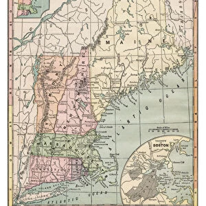
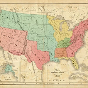
Map of the USA Northeastern section 1897

![]()
Wall Art and Photo Gifts from Fine Art Storehouse
Map of the USA Northeastern section 1897
Natural Elementary Geography by Redway and Hinman - NY/Cincinnati/Chicago 1897
Unleash your creativity and transform your space into a visual masterpiece!
THEPALMER
Media ID 18356689
FEATURES IN THESE COLLECTIONS
> Fine Art Storehouse
> Map
> Historical Maps
> Fine Art Storehouse
> Map
> USA Maps
> Maps and Charts
> Early Maps
> North America
> United States of America
> Maps
EDITORS COMMENTS
This photo print, titled "Map of the USA Northeastern section 1897" takes us on a visual journey back in time. A relic from the past, it showcases an intricate cartographic masterpiece that was originally featured in the renowned textbook "Natural Elementary Geography" by Redway and Hinman, published in New York, Cincinnati, and Chicago in 1897. The map itself is a testament to the artistry and precision of its creators. With meticulous attention to detail, every contour of this northeastern section of the United States comes alive on paper. From sprawling coastlines to winding rivers and majestic mountain ranges, each element is expertly depicted with remarkable accuracy. As we gaze upon this vintage treasure through THEPALMER's lens, we are transported to an era when maps were not just navigational tools but also works of art. The faded hues lend an air of nostalgia while adding depth to our understanding of how these regions have evolved over time. Beyond its historical significance lies another layer: a reminder that knowledge has always been at our fingertips waiting to be explored. This photograph invites us to appreciate both the beauty inherent in nature's geography as well as humanity's quest for understanding it. Whether displayed proudly on a wall or cherished within a personal collection, this print serves as a tangible link between past and present—a timeless tribute to exploration and discovery.
MADE IN THE USA
Safe Shipping with 30 Day Money Back Guarantee
FREE PERSONALISATION*
We are proud to offer a range of customisation features including Personalised Captions, Color Filters and Picture Zoom Tools
SECURE PAYMENTS
We happily accept a wide range of payment options so you can pay for the things you need in the way that is most convenient for you
* Options may vary by product and licensing agreement. Zoomed Pictures can be adjusted in the Cart.