Home > North America > United States of America > Indiana > Indianapolis
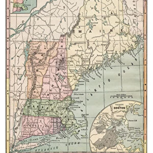
New England States map 1889

![]()
Wall Art and Photo Gifts from Fine Art Storehouse
New England States map 1889
Indiana Educational Series The Complete Geography - Indianapolis 1889
Unleash your creativity and transform your space into a visual masterpiece!
THEPALMER
Media ID 14756298
© This content is subject to copyright
Connecticut Maine Massachusetts New England New Hampshire Rhode Island Vermont
FEATURES IN THESE COLLECTIONS
> Europe
> France
> Canton
> Maine
> Europe
> United Kingdom
> England
> Hampshire
> Related Images
> Europe
> United Kingdom
> England
> Maps
> Fine Art Storehouse
> Map
> Historical Maps
> Maps and Charts
> Early Maps
> North America
> United States of America
> Indiana
> Indianapolis
EDITORS COMMENTS
This print showcases a historical gem, the "New England States map 1889" part of the Indiana Educational Series The Complete Geography collection from Indianapolis in 1889. Crafted by THEPALMER, this exquisite piece takes us back to a time when cartography was an art form in itself. The map depicts the enchanting region of New England with remarkable precision and attention to detail. From Connecticut's charming coastal towns to Vermont's picturesque landscapes, every state is beautifully represented. Rhode Island's quaint charm and New Hampshire's majestic mountains are brought to life through intricate lines and delicate shading. Meanwhile, Maine's rugged coastline and Massachusetts' rich history come alive on this vintage masterpiece. As we gaze upon this stunning print, we can't help but marvel at the craftsmanship that went into its creation over a century ago. It serves as a testament to both the artistic talent of THEPALMER and the importance placed on geographical knowledge during that era. Whether you're an avid historian or simply appreciate fine art, this print transports you back in time while offering a glimpse into America's past. Its timeless beauty makes it an ideal addition for any home or office decor, sparking conversations about our nation's heritage and igniting curiosity about these iconic New England states.
MADE IN THE USA
Safe Shipping with 30 Day Money Back Guarantee
FREE PERSONALISATION*
We are proud to offer a range of customisation features including Personalised Captions, Color Filters and Picture Zoom Tools
SECURE PAYMENTS
We happily accept a wide range of payment options so you can pay for the things you need in the way that is most convenient for you
* Options may vary by product and licensing agreement. Zoomed Pictures can be adjusted in the Cart.