Metal Print > Arts > Artists > O > Oceanic Oceanic
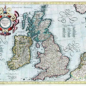
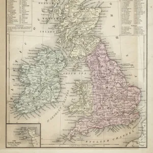
Metal Print : Map of British Isles, lithograph, lithograph, published in 1876


![]()
Metal Prints from Fine Art Storehouse
Map of British Isles, lithograph, lithograph, published in 1876
Map of British Isles. Lithograph, published in 1876
Unleash your creativity and transform your space into a visual masterpiece!
Media ID 13666749
© ZU_09
Atlantic Ocean British Culture Contour Drawing English Culture European Culture Iceland Irish Culture Island North Sea Republic Of Ireland Scotland Scottish Culture Topographic Map Topography Wales Scotch Whisky Shetland Islands Stephen Ireland
16"x20" (51x41cm) Metal Print
Discover the rich history of the British Isles with our stunning Metal Print of this intricately detailed 1876 lithograph. This vintage map, published over a century ago, showcases the intricacies of the British Isles in a new light. The high-quality Metal Print process enhances the vibrant colors and textures of the original lithograph, creating a captivating piece of art that's sure to be a conversation starter in any home or office. Bring a touch of history and elegance to your space with this beautiful and unique addition to your decor.
Made with durable metal and luxurious printing techniques, our metal photo prints go beyond traditional canvases, adding a cool, modern touch to your space. Wall mount on back. Eco-friendly 100% post-consumer recycled ChromaLuxe aluminum surface. The thickness of the print is 0.045". Featuring a Scratch-resistant surface and Rounded corners. Backing hangers are attached to the back of the print and float the print 1/2-inch off the wall when hung, the choice of hanger may vary depending on size and International orders will come with Float Mount hangers only. Finished with a brilliant white high gloss surface for unsurpassed detail and vibrance. Printed using Dye-Sublimation and for best care we recommend a non-ammonia glass cleaner, water, or isopropyl (rubbing) alcohol to prevent harming the print surface. We recommend using a clean, lint-free cloth to wipe off the print. The ultra-hard surface is scratch-resistant, waterproof and weatherproof. Avoid direct sunlight exposure.
Made with durable metal and luxurious printing techniques, metal prints bring images to life and add a modern touch to any space
Estimated Image Size (if not cropped) is 40.6cm x 50.8cm (16" x 20")
Estimated Product Size is 41.2cm x 51.4cm (16.2" x 20.2")
These are individually made so all sizes are approximate
Artwork printed orientated as per the preview above, with portrait (vertical) orientation to match the source image.
FEATURES IN THESE COLLECTIONS
> Fine Art Storehouse
> Map
> Historical Maps
> Arts
> Artists
> O
> Oceanic Oceanic
> Europe
> Iceland
> Related Images
> Europe
> Related Images
> Europe
> Republic of Ireland
> Maps
> Europe
> Republic of Ireland
> Related Images
> Europe
> United Kingdom
> England
> Maps
> Europe
> United Kingdom
> England
> Posters
> Europe
> United Kingdom
> England
> Related Images
EDITORS COMMENTS
This lithograph, published in 1876, showcases a meticulously detailed Map of the British Isles. A true testament to the artistry and precision of cartography during that era, this antique print offers a glimpse into European culture and history. Engraved with utmost care, the topographic map reveals the intricate coastline of England, Wales, Scotland, and even includes the Shetland Islands. The Republic of Ireland is also featured prominently on this vertical composition. As one's gaze explores this masterpiece further, it becomes evident that it captures not only geographical information but also hints at ancient traditions and cultural nuances. The image transports us back in time as we envision English culture thriving along its shores while Irish customs flourish inland. The Scottish flag proudly waves amidst breathtaking landscapes dotted with distilleries producing renowned Scotch whisky. Surrounding these enchanting islands are vast expanses of the North Sea and Atlantic Ocean. This lithograph serves as a visual portal to explore Europe's diverse island heritage. Its contour drawing evokes nostalgia for times gone by while offering an opportunity to appreciate the beauty of nature untouched by human presence. Preserved over centuries, this remarkable artwork continues to captivate viewers with its historical significance and artistic brilliance. It stands as a testament to Stephen Ireland's skillful photography in capturing such an exquisite piece from our past.
MADE IN THE USA
Safe Shipping with 30 Day Money Back Guarantee
FREE PERSONALISATION*
We are proud to offer a range of customisation features including Personalised Captions, Color Filters and Picture Zoom Tools
SECURE PAYMENTS
We happily accept a wide range of payment options so you can pay for the things you need in the way that is most convenient for you
* Options may vary by product and licensing agreement. Zoomed Pictures can be adjusted in the Cart.