Metal Print > Africa > Egypt > Maps
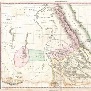
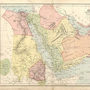
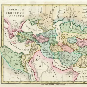
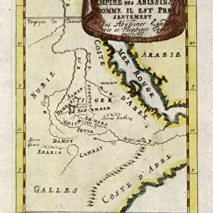
Metal Print : Antique map of Middle East with Arabia, Egypt, Nubia, and Abyssinia


![]()
Metal Prints from Fine Art Storehouse
Antique map of Middle East with Arabia, Egypt, Nubia, and Abyssinia
Unleash your creativity and transform your space into a visual masterpiece!
Hemera Technologies
Media ID 13609417
© Getty Images
Abyssinia Arabia Border Coordinates Direction Document Egypt Ethiopia Geography Horn Horn Of Africa Indian Ocean Israel Jordan Jordan Middle East Latitude Legend Libya Location Longitude Middle East Nile River Nubia Persian Gulf Place Positioning Red Sea Scale Sudan Lybia
16"x20" (51x41cm) Metal Print
Step back in time with our exquisite Antique Map of the Middle East print from Hemera Technologies, available at Media Storehouse's Fine Art Storehouse. This captivating map transports you to a bygone era, featuring intricate details of Arabia, Egypt, Nubia, and Abyssinia. The rich, antiqued hues and intricate lines bring history to life, making this a stunning addition to any home or office decor. Order now and let the allure of the past enchant your space.
Made with durable metal and luxurious printing techniques, our metal photo prints go beyond traditional canvases, adding a cool, modern touch to your space. Wall mount on back. Eco-friendly 100% post-consumer recycled ChromaLuxe aluminum surface. The thickness of the print is 0.045". Featuring a Scratch-resistant surface and Rounded corners. Backing hangers are attached to the back of the print and float the print 1/2-inch off the wall when hung, the choice of hanger may vary depending on size and International orders will come with Float Mount hangers only. Finished with a brilliant white high gloss surface for unsurpassed detail and vibrance. Printed using Dye-Sublimation and for best care we recommend a non-ammonia glass cleaner, water, or isopropyl (rubbing) alcohol to prevent harming the print surface. We recommend using a clean, lint-free cloth to wipe off the print. The ultra-hard surface is scratch-resistant, waterproof and weatherproof. Avoid direct sunlight exposure.
Made with durable metal and luxurious printing techniques, metal prints bring images to life and add a modern touch to any space
Estimated Image Size (if not cropped) is 50.8cm x 40.6cm (20" x 16")
Estimated Product Size is 51.4cm x 41.2cm (20.2" x 16.2")
These are individually made so all sizes are approximate
Artwork printed orientated as per the preview above, with landscape (horizontal) orientation to match the source image.
FEATURES IN THESE COLLECTIONS
> Fine Art Storehouse
> Map
> Historical Maps
> Africa
> Egypt
> Related Images
> Africa
> Ethiopia (Abyssinia)
> Maps
> Africa
> Ethiopia (Abyssinia)
> Related Images
> Africa
> Ethiopia
> Related Images
> Africa
> Libya
> Related Images
> Africa
> Related Images
> Africa
> Sudan
> Related Images
EDITORS COMMENTS
This antique map of the Middle East takes us on a journey through time, unraveling the rich history and geography of this fascinating region. Printed by Hemera Technologies, it showcases Arabia, Egypt, Nubia, and Abyssinia in intricate detail. The map's archival quality transports us back to an era when cartography was both an art form and a scientific endeavor. Its delicate engravings depict borders, coordinates, and legends that guide our exploration. From the Persian Gulf to the Red Sea and from Israel to Sudan, every place is meticulously labeled with its longitude and latitude. As we trace the Nile River snaking through Egypt or follow the Horn of Africa jutting into the Indian Ocean, we are reminded of how physical geography has shaped civilizations over centuries. The absence of people in this image allows us to focus solely on nature's influence on human history. With its warm color palette and horizontal composition, this vintage print exudes a sense of nostalgia that invites contemplation. It serves as a reminder that understanding our past is essential for comprehending our present reality. Whether you are an avid historian or simply appreciate fine art photography, this antique map offers endless possibilities for discovery. Let it transport you across ancient lands while igniting your curiosity about cultures long gone but not forgotten.
MADE IN THE USA
Safe Shipping with 30 Day Money Back Guarantee
FREE PERSONALISATION*
We are proud to offer a range of customisation features including Personalised Captions, Color Filters and Picture Zoom Tools
SECURE PAYMENTS
We happily accept a wide range of payment options so you can pay for the things you need in the way that is most convenient for you
* Options may vary by product and licensing agreement. Zoomed Pictures can be adjusted in the Cart.