Metal Print > Europe > Russia > Maps
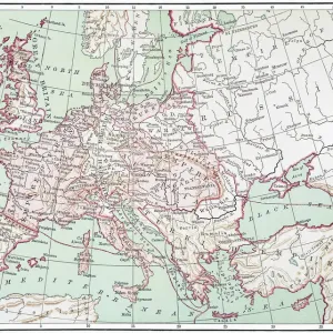
Metal Print : Map of Europe after the Peace of Tilsit in 1807, from A Short History of the


![]()
Metal Prints from Fine Art Finder
Map of Europe after the Peace of Tilsit in 1807, from A Short History of the
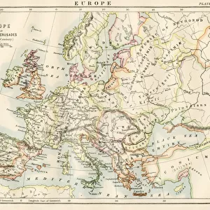
KW392529 Map of Europe after the Peace of Tilsit in 1807, from A Short History of the English People by J. R. Green, published 1893 (colour litho) by English School, (19th century); Private Collection; (add.info.: The Treaties of Tilsit were two agreements signed by Napoleon I of France in the town of Tilsit in July, 1807 in the aftermath of his victory at Friedland. The first was signed on 7 July, between Tsar Alexander I of Russia and Napoleon. The second was signed with Prussia on 9 July. The treaties ended the War of the Fourth Coalition at the expense of the Prussian king, who had already agreed to a truce on 25 June after the Grande Armee had pursued him to the easternmost frontier of his realm, and in Tilsit ceded about half of his pre-war territories. From those territories, Napoleon had created French client states: the Kingdom of Westphalia, the Duchy of Warsaw and the Free City of Danzig; the other ceded territories were awarded to further French clients and to Russia.
); Ken Welsh; English, out of copyright
Media ID 12871960
© www.bridgemanimages.com
Borders Countries Diagram Empires Frontiers Napoleonic Region Regions Territories Territory Treaty
16"x20" (51x41cm) Metal Print
Step back in time with our stunning Metal Print of the Map of Europe after the Peace of Tilsit in 1807, taken from A Short History of the English People by J.R. Green. This intricately detailed antique map showcases Europe's political landscape during a pivotal moment in history. The vibrant colors and sharp lines are brought to life on high-quality metal, creating a unique and eye-catching piece for your home or office. Add a touch of history and sophistication to your space with this beautiful and informative work of art from Media Storehouse and Bridgeman Images.
Made with durable metal and luxurious printing techniques, our metal photo prints go beyond traditional canvases, adding a cool, modern touch to your space. Wall mount on back. Eco-friendly 100% post-consumer recycled ChromaLuxe aluminum surface. The thickness of the print is 0.045". Featuring a Scratch-resistant surface and Rounded corners. Backing hangers are attached to the back of the print and float the print 1/2-inch off the wall when hung, the choice of hanger may vary depending on size and International orders will come with Float Mount hangers only. Finished with a brilliant white high gloss surface for unsurpassed detail and vibrance. Printed using Dye-Sublimation and for best care we recommend a non-ammonia glass cleaner, water, or isopropyl (rubbing) alcohol to prevent harming the print surface. We recommend using a clean, lint-free cloth to wipe off the print. The ultra-hard surface is scratch-resistant, waterproof and weatherproof. Avoid direct sunlight exposure.
Made with durable metal and luxurious printing techniques, metal prints bring images to life and add a modern touch to any space
Estimated Image Size (if not cropped) is 50.8cm x 40.6cm (20" x 16")
Estimated Product Size is 51.4cm x 41.2cm (20.2" x 16.2")
These are individually made so all sizes are approximate
Artwork printed orientated as per the preview above, with landscape (horizontal) orientation to match the source image.
FEATURES IN THESE COLLECTIONS
> Fine Art Finder
> Schools
> English School
> Europe
> Related Images
> Europe
> Russia
> Related Images
> Maps and Charts
> Early Maps
> Maps and Charts
> Related Images
EDITORS COMMENTS
This print showcases a vibrant and detailed "Map of Europe after the Peace of Tilsit in 1807". Published in 1893 as part of J. R. Green's "A Short History of the English People" this color lithograph provides a visual representation of the geopolitical changes that occurred following Napoleon I's victory at Friedland. The Treaties of Tilsit, signed by Napoleon and Tsar Alexander I on July 7,1807, marked a significant turning point in European history. This agreement effectively ended the War of the Fourth Coalition and reshaped the continent's political landscape. The Prussian king, who had already agreed to a truce prior to these treaties, was forced to cede about half of his pre-war territories. Napoleon utilized these acquired lands to establish French client states such as the Kingdom of Westphalia, Duchy of Warsaw, and Free City of Danzig. Additionally, other ceded territories were distributed among further French clients and Russia. The map itself is intricately designed with precise borders delineating each nation-state affected by this historic event. Its vivid colors bring life to an era defined by shifting alliances and power struggles across Europe. As we gaze upon this remarkable piece from our private collection, we are reminded not only of its artistic beauty but also its historical significance—a testament to how peace treaties can shape nations for generations to come.
MADE IN THE USA
Safe Shipping with 30 Day Money Back Guarantee
FREE PERSONALISATION*
We are proud to offer a range of customisation features including Personalised Captions, Color Filters and Picture Zoom Tools
SECURE PAYMENTS
We happily accept a wide range of payment options so you can pay for the things you need in the way that is most convenient for you
* Options may vary by product and licensing agreement. Zoomed Pictures can be adjusted in the Cart.