Metal Print > Historic > Ancient civilizations > Ancient Greece > Greek history
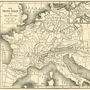
Metal Print : Map of Epirus and western Greece, 295 BC. From Cassells Universal History, published 1888


![]()
Metal Prints From Design Pics
Map of Epirus and western Greece, 295 BC. From Cassells Universal History, published 1888
Design Pics offers Distinctively Different Imagery representing over 1,500 contributors
Media ID 24906861
© Ken Welsh
Ancient Cartography Geographical Geography Greece Greek
20"x24" (61x51cm) Metal Print
Discover the rich history of ancient Greece with our stunning Metal Print of a Map of Epirus and Western Greece, dating back to 295 BC. This intricately detailed map, taken from the pages of Cassells Universal History published in 1888, showcases the historical landscape of the region during the Hellenistic period. Bring history to life in your home or office with this high-quality Metal Print, featuring vibrant colors and a sleek, modern design. The metal print is not only an attractive decor piece but also a conversation starter, perfect for history enthusiasts and collectors. Order now and step back in time to explore the ancient world like never before.
Made with durable metal and luxurious printing techniques, our metal photo prints go beyond traditional canvases, adding a cool, modern touch to your space. Wall mount on back. Eco-friendly 100% post-consumer recycled ChromaLuxe aluminum surface. The thickness of the print is 0.045". Featuring a Scratch-resistant surface and Rounded corners. Backing hangers are attached to the back of the print and float the print 1/2-inch off the wall when hung, the choice of hanger may vary depending on size and International orders will come with Float Mount hangers only. Finished with a brilliant white high gloss surface for unsurpassed detail and vibrance. Printed using Dye-Sublimation and for best care we recommend a non-ammonia glass cleaner, water, or isopropyl (rubbing) alcohol to prevent harming the print surface. We recommend using a clean, lint-free cloth to wipe off the print. The ultra-hard surface is scratch-resistant, waterproof and weatherproof. Avoid direct sunlight exposure.
Made with durable metal and luxurious printing techniques, metal prints bring images to life and add a modern touch to any space
Estimated Image Size (if not cropped) is 60.9cm x 50.8cm (24" x 20")
Estimated Product Size is 61.5cm x 51.4cm (24.2" x 20.2")
These are individually made so all sizes are approximate
Artwork printed orientated as per the preview above, with landscape (horizontal) orientation to match the source image.
FEATURES IN THESE COLLECTIONS
> Europe
> Greece
> Related Images
> Historic
> Ancient civilizations
> Ancient Greece
> Greek history
> Maps and Charts
> Early Maps
EDITORS COMMENTS
This print showcases a remarkable piece of history - the Map of Epirus and western Greece, dating back to 295 BC. Taken from Cassells Universal History, published in 1888, this ancient map offers a glimpse into the past and allows us to explore the geographical landscape of Greece during that period. The intricate details engraved on this archival piece provide an invaluable resource for historians and cartographers alike. It beautifully captures the essence of Greek culture and its significant influence on Western civilization. The careful craftsmanship evident in this vintage illustration transports us back in time, allowing us to visualize how these regions were shaped centuries ago. As we study this picture, we can't help but marvel at the historical significance it holds. It serves as a reminder of our collective heritage and provides insight into the political boundaries, cities, rivers, mountains, and other geographic features that defined Epirus and western Greece at that time. Ken Welsh's expertise is apparent in his preservation of such an important artifact through photography. This image not only preserves history but also sparks curiosity about ancient civilizations and their impact on our present-day world. Whether you are a lover of history or simply fascinated by ancient cultures, this print is sure to captivate your imagination as you delve into the rich tapestry of Greek geography from over two millennia ago.
MADE IN THE USA
Safe Shipping with 30 Day Money Back Guarantee
FREE PERSONALISATION*
We are proud to offer a range of customisation features including Personalised Captions, Color Filters and Picture Zoom Tools
SECURE PAYMENTS
We happily accept a wide range of payment options so you can pay for the things you need in the way that is most convenient for you
* Options may vary by product and licensing agreement. Zoomed Pictures can be adjusted in the Basket.