Fine Art Print > Historic > Ancient civilizations > Ancient Greece > Greek history
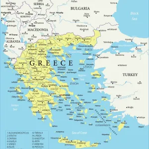
Fine Art Print : Map of Epirus and western Greece, 295 BC. From Cassells Universal History, published 1888

![]()
Fine Art Prints From Design Pics
Map of Epirus and western Greece, 295 BC. From Cassells Universal History, published 1888
Design Pics offers Distinctively Different Imagery representing over 1,500 contributors
Media ID 24906861
© Ken Welsh
Ancient Cartography Geographical Geography Greece Greek
20"x20" (+3" Border) Fine Art Print
Discover the rich history of ancient Greece with our exquisite Fine Art Print of the Map of Epirus and Western Greece from Cassells Universal History, published in 1888. This intricately detailed map, captured by Ken Welsh from Design Pics, transports you back in time to 295 BC. Explore the territories of Epirus and Western Greece as they once were, and add a touch of history and culture to your home or office décor. Our high-quality Fine Art Prints are printed on premium paper using archival inks, ensuring your investment is a long-lasting and beautiful addition to your space.
20x20 image printed on 26x26 Fine Art Rag Paper with 3" (76mm) white border. Our Fine Art Prints are printed on 300gsm 100% acid free, PH neutral paper with archival properties. This printing method is used by museums and art collections to exhibit photographs and art reproductions.
Our fine art prints are high-quality prints made using a paper called Photo Rag. This 100% cotton rag fibre paper is known for its exceptional image sharpness, rich colors, and high level of detail, making it a popular choice for professional photographers and artists. Photo rag paper is our clear recommendation for a fine art paper print. If you can afford to spend more on a higher quality paper, then Photo Rag is our clear recommendation for a fine art paper print.
Estimated Image Size (if not cropped) is 50.8cm x 47.5cm (20" x 18.7")
Estimated Product Size is 66cm x 66cm (26" x 26")
These are individually made so all sizes are approximate
Artwork printed orientated as per the preview above, with landscape (horizontal) orientation to match the source image.
FEATURES IN THESE COLLECTIONS
> Europe
> Greece
> Related Images
> Historic
> Ancient civilizations
> Ancient Greece
> Greek history
> Maps and Charts
> Early Maps
EDITORS COMMENTS
This print showcases a remarkable piece of history - the Map of Epirus and western Greece, dating back to 295 BC. Taken from Cassells Universal History, published in 1888, this ancient map offers a glimpse into the past and allows us to explore the geographical landscape of Greece during that period. The intricate details engraved on this archival piece provide an invaluable resource for historians and cartographers alike. It beautifully captures the essence of Greek culture and its significant influence on Western civilization. The careful craftsmanship evident in this vintage illustration transports us back in time, allowing us to visualize how these regions were shaped centuries ago. As we study this picture, we can't help but marvel at the historical significance it holds. It serves as a reminder of our collective heritage and provides insight into the political boundaries, cities, rivers, mountains, and other geographic features that defined Epirus and western Greece at that time. Ken Welsh's expertise is apparent in his preservation of such an important artifact through photography. This image not only preserves history but also sparks curiosity about ancient civilizations and their impact on our present-day world. Whether you are a lover of history or simply fascinated by ancient cultures, this print is sure to captivate your imagination as you delve into the rich tapestry of Greek geography from over two millennia ago.
MADE IN THE USA
Safe Shipping with 30 Day Money Back Guarantee
FREE PERSONALISATION*
We are proud to offer a range of customisation features including Personalised Captions, Color Filters and Picture Zoom Tools
SECURE PAYMENTS
We happily accept a wide range of payment options so you can pay for the things you need in the way that is most convenient for you
* Options may vary by product and licensing agreement. Zoomed Pictures can be adjusted in the Basket.