Home > Europe > United Kingdom > Northern Ireland > Posters
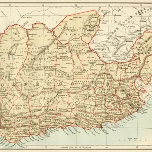
A Map Of Irish Free State And Northern Ireland

![]()
Wall Art and Photo Gifts from Mary Evans Picture Library
A Map Of Irish Free State And Northern Ireland
a, map, of, irish, free, state, and, northern, ireland, 1929, truly, outstanding, large, scale, empire, marketing, board, poster, designed, by, leslie, macdonald, max, gill, this, design, for, the, was, published, in, as, part, series, celebrating, produce, british, isles, its, dominions, namely, south, africa, canada, new, zealand, australia, they, were, intended, public, display, often, on, specially, erected, hoardings, today, these, extremely, scare, beautiful, posters, rarely, appear, market, example, came, from, estate, would, have, been, retained, reference, copy. artwork, publisher, , 13748184
Mary Evans Picture Library makes available wonderful images created for people to enjoy over the centuries
Media ID 32254486
© Mary Evans Picture Library 2021
Beautiful Celebrating Copy Dominions Erected Estate Extremely Free Gill Hoardings Intended Isles Leslie Macdonald Marketing Outstanding Produce Publisher Rarely Reference Retained Scale Scare Specially Today Zealand 1929 Designed
FEATURES IN THESE COLLECTIONS
> Africa
> South Africa
> Maps
> Europe
> Republic of Ireland
> Maps
> Europe
> United Kingdom
> Northern Ireland
> Maps
> Europe
> United Kingdom
> Northern Ireland
> Posters
> Mary Evans Prints Online
> New Images July 2023
> North America
> Canada
> Maps
> Oceania
> New Zealand
> Maps
EDITORS COMMENTS
This stunning large-scale map print, depicting the Irish Free State and Northern Ireland from 1929, is a truly outstanding example of the Empire Marketing Board's promotional posters designed to celebrate the British Isles and its dominions. Designed by Leslie Macdonald and Max Gill, this map was published as part of a series that included South Africa, Canada, New Zealand, and Australia. The posters were intended for public display, often on specially erected hoardings, and were a testament to the pride and sense of unity felt towards the British Empire at the time. The map's intricate detail and vibrant colors make it a beautiful piece of art, showcasing the political divisions of the Irish Free State and Northern Ireland during that era. The Empire Marketing Board, which commissioned the poster, was established in 1926 to promote trade and commerce within the British Empire. This map, with its intricate detail and eye-catching design, would have been a valuable reference for those interested in the geography and politics of the British Isles and its dominions. Today, these posters are extremely rare and seldom appear on the market. The example shown here comes from a private estate and would have been retained as a reference copy. The map's intricate design and historical significance make it a valuable addition to any collection of vintage maps or British Empire memorabilia.
MADE IN THE USA
Safe Shipping with 30 Day Money Back Guarantee
FREE PERSONALISATION*
We are proud to offer a range of customisation features including Personalised Captions, Color Filters and Picture Zoom Tools
SECURE PAYMENTS
We happily accept a wide range of payment options so you can pay for the things you need in the way that is most convenient for you
* Options may vary by product and licensing agreement. Zoomed Pictures can be adjusted in the Cart.