Home > Animals > Mammals > Didelphidae > Formosa
Map of Asia, early 19th century

![]()
Wall Art and Photo Gifts from Mary Evans Picture Library
Map of Asia, early 19th century
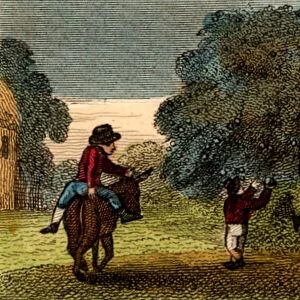
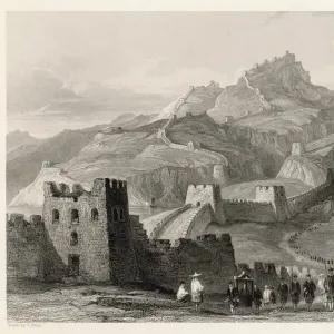
Map of Asia, early 19th century. Showing Asia Minor, Arabia, Persia, Siberia, Tartary, Thibet, Hindoostan, Further India, China, Formosa, Japan. Handcoloured copperplate engraving from Rev. Isaac Taylors Scenes in Asia, for the Amusement and Instruction of Little Tarry-at-Home Travelers, John Harris, London, 1819
Mary Evans Picture Library makes available wonderful images created for people to enjoy over the centuries
Media ID 23391740
© Florilegius
Amusement Camellia Customers Educational Georgian Harvest Instruction Isaac Regency Shopkeepers Sinensis Tarry Taylor Childrens
FEATURES IN THESE COLLECTIONS
> Animals
> Mammals
> Didelphidae
> Formosa
> Arts
> Artists
> T
> Isaac Taylor
> Asia
> China
> China Heritage Sites
> The Great Wall
> Europe
> United Kingdom
> England
> London
> Related Images
> Historic
> Ancient civilizations
> Great Wall of China
> Maps and Charts
> Early Maps
> Mary Evans Prints Online
> New Images August 2021
EDITORS COMMENTS
Step into the early 19th century with this handcoloured copperplate engraving of Asia, a fascinating and intriguing continent that was just beginning to be explored and understood by the Western world. This map, taken from Rev. Isaac Taylor's "Scenes in Asia," published in London in 1819, provides a detailed and colourful depiction of Asia Minor, Arabia, Persia, Siberia, Tartary, Thibet, Hindoostan, Further India, China, Formosa, and Japan. The map offers a glimpse into the diverse and rich cultures that flourished across Asia during this period. In the center, the vast expanse of China is depicted, with the Great Wall snaking its way through the mountainous terrain. A bustling Chinese town scene unfolds at the bottom of the map, showcasing the vibrant street life of the time. Shopkeepers attend to customers, workers toil away, and the harvest is brought in. The map also highlights the important role of tea in Chinese culture, with tea leaves and the camellia sinensis plant depicted in the foreground. Elsewhere on the map, the rich textures and colours of the Middle East are brought to life, with the deserts of Arabia and the mountains of Persia depicted in intricate detail. The map also reveals the vastness of Russia, with Siberia and Tartary stretching across the northern reaches of the continent. This map is not only a historical record of the early 19th century, but also an educational tool and a work of art. It invites us to explore the wonders of Asia and to learn about the diverse cultures and landscapes that make up this remarkable continent. The intricate handcolouring and detailed engraving make this a beautiful addition to any collection, and a fascinating glimpse into the past.
MADE IN THE USA
Safe Shipping with 30 Day Money Back Guarantee
FREE PERSONALISATION*
We are proud to offer a range of customisation features including Personalised Captions, Color Filters and Picture Zoom Tools
SECURE PAYMENTS
We happily accept a wide range of payment options so you can pay for the things you need in the way that is most convenient for you
* Options may vary by product and licensing agreement. Zoomed Pictures can be adjusted in the Cart.