Home > Popular Themes > Steamship
GPO map of Mail Steamship Routes

![]()
Wall Art and Photo Gifts from Mary Evans Picture Library
GPO map of Mail Steamship Routes
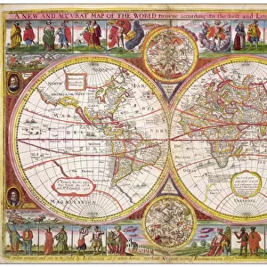
GPO map of Mail Steamship Routes. Date: circa 1950s
Mary Evans Picture Library makes available wonderful images created for people to enjoy over the centuries
Media ID 14311985
© Mary Evans Picture Library/Onslow Auctions Limited
Atlantic Communication Cruise Mail Maps Oceans Pacific Pictorial Postal Route Routes Seas Steamship Liner
FEATURES IN THESE COLLECTIONS
> Maps and Charts
> Early Maps
> Maps and Charts
> World
EDITORS COMMENTS
1. Title: "Voyages of Discovery: A 1950s GPO Map Illustrating Mail Steamship Routes Around the World" This vintage map print, published by the Government Printing Office (GPO) in the 1950s, offers a fascinating glimpse into the world of mail steamship routes that crisscrossed the Atlantic and Pacific Oceans during the mid-20th century. The map, a testament to the era's spirit of travel and communication, showcases the extensive network of shipping lanes that connected countries and continents, fostering global connections and facilitating the exchange of goods, ideas, and people. The map's intricate details reveal the major mail steamship routes that traversed the Indian Ocean, Atlantic, and Pacific, with an emphasis on the transatlantic and transpacific voyages. The vibrant colors and clear labeling make it easy to follow the various shipping lanes, which were essential for the postal service during this period. The map also highlights key ports of call, including major cities and countries, adding to its historical and geographical significance. The 1950s was an era of growing leisure travel and tourism, and this map serves as a reminder of the role mail steamships played in making long-distance travel more accessible to the masses. The ships themselves were a marvel of engineering, offering passengers a chance to experience the thrill of ocean travel while enjoying the comforts of a floating city. This map, with its rich history and intriguing details, invites us to explore the world's vast oceans and the incredible stories they hold. Whether you're an avid collector of vintage maps, a history buff, or simply someone who appreciates the beauty of cartography, this 1950s GPO map of mail steamship routes is a must-have addition to your collection. It's a captivating reminder of a bygone era when the world seemed a little smaller, and the possibilities for exploration seemed endless.
MADE IN THE USA
Safe Shipping with 30 Day Money Back Guarantee
FREE PERSONALISATION*
We are proud to offer a range of customisation features including Personalised Captions, Color Filters and Picture Zoom Tools
SECURE PAYMENTS
We happily accept a wide range of payment options so you can pay for the things you need in the way that is most convenient for you
* Options may vary by product and licensing agreement. Zoomed Pictures can be adjusted in the Cart.