Home > Arts > Artists > T > John Tallis
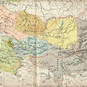
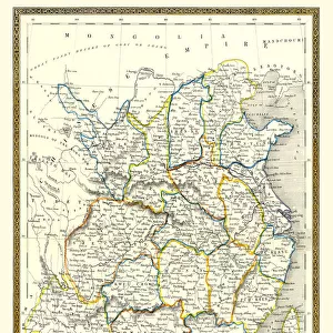
Tibet, Mongolia and Manchuria 1851

![]()
Wall Art and Photo Gifts from MapSeeker
Tibet, Mongolia and Manchuria 1851
A fine facimile artworked from an antique original map of Tibet, Mongolia and Manchuria, issued as part of the 1851 edition of John Tallis and Companys " The Illustrated Atlas and Modern History of the World"
Welcome to the Mapseeker Image library and enter an historic gateway to one of the largest on-line collections of Historic Maps, Nostalgic Views, Vista's and Panorama's from a World gone by.
Media ID 20347354
© Mapseeker Publishing Ltd
John Tallis John Tallis Map Tallis Map Mongolia Tibet
FEATURES IN THESE COLLECTIONS
> Arts
> Artists
> T
> John Tallis
> Asia
> Mongolia
> Related Images
> Maps and Charts
> Related Images
> Maps and Charts
> World
> MapSeeker
> Maps of Asia and Middle East
> Maps of Countries in Asia PORTFOLIO
EDITORS COMMENTS
This stunning print captures the essence of a bygone era, showcasing an antique original map of Tibet, Mongolia, and Manchuria from 1851. The intricate details and exquisite craftsmanship make it a true work of art. The map is a fine facsimile artworked from the original edition found in John Tallis and Company's "The Illustrated Atlas and Modern History of the World". It offers a glimpse into the geographical landscape and historical significance of these regions during that time period. Tibet, with its majestic mountain ranges and spiritual allure, takes center stage on this map. The old Tibetan map reveals ancient cities, monasteries, trade routes, and cultural landmarks that have shaped this mystical land for centuries. Mongolia's vast steppes come to life through delicate illustrations depicting nomadic tribes traversing across their ancestral territories. This visual representation showcases Mongolia's rich heritage as well as its close connection to nature. Manchuria completes this triad of enchantment with its lush forests, mighty rivers, and flourishing agricultural lands. The detailed cartography highlights important cities along with key natural features that have played significant roles in shaping Manchurian history. This print serves as both an educational resource for history enthusiasts and a beautiful piece of decor for any space seeking to evoke a sense of wanderlust or appreciation for our world's diverse cultures.
MADE IN THE USA
Safe Shipping with 30 Day Money Back Guarantee
FREE PERSONALISATION*
We are proud to offer a range of customisation features including Personalised Captions, Color Filters and Picture Zoom Tools
SECURE PAYMENTS
We happily accept a wide range of payment options so you can pay for the things you need in the way that is most convenient for you
* Options may vary by product and licensing agreement. Zoomed Pictures can be adjusted in the Cart.