Home > Arts > Literature > Magazines
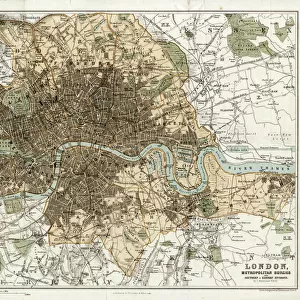
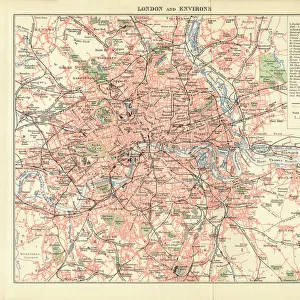
1764, Gentlemans Magazine Map of London and Environs, topography, cartography

![]()
Wall Art and Photo Gifts from Liszt Collection
1764, Gentlemans Magazine Map of London and Environs, topography, cartography
1764, Gentlemans Magazine Map of London and Environs
Liszt Collection of nineteenth-century engravings and images to browse and enjoy
Media ID 14004653
© Artokoloro Quint Lox Limited
1764 Antique Map Atlas Chart Geographic Latitude Longitude Mappa Mundi Old Antique Plan Old Antique View Old Map Ols Antique Map Rare Old Maps Topo
FEATURES IN THESE COLLECTIONS
> Arts
> Literature
> Magazines
> Europe
> United Kingdom
> England
> London
> Related Images
> Maps and Charts
> Early Maps
> Maps and Charts
> World
EDITORS COMMENTS
This print showcases the remarkable "1764, Gentlemans Magazine Map of London and Environs". A true masterpiece in topography and cartography, this vintage map takes us on a journey through time to explore the rich history and geography of one of the world's most iconic cities. With its intricate details and precise measurements, this ancient map offers a glimpse into the past, revealing how London's landscape has evolved over centuries. The carefully illustrated landmarks, streets, and rivers provide an invaluable resource for historians and enthusiasts alike. The artistry displayed in this decorative piece is awe-inspiring. The delicate lines forming a grid of latitude and longitude create a geometric harmony that adds to its visual appeal. Its aged appearance adds an air of nostalgia, reminding us of the countless journeys made by those who relied on such maps for navigation. As we gaze upon this rare artifact from another era, we are transported back in time. We can almost imagine ourselves walking along these historic streets or embarking on grand adventures across unexplored territories. Whether you're an avid collector or simply fascinated by historical artifacts, this exquisite print is sure to captivate your imagination. It serves as a testament to human curiosity and our innate desire to understand the world around us. Let it inspire you to embark on your own journey of discovery!
MADE IN THE USA
Safe Shipping with 30 Day Money Back Guarantee
FREE PERSONALISATION*
We are proud to offer a range of customisation features including Personalised Captions, Color Filters and Picture Zoom Tools
SECURE PAYMENTS
We happily accept a wide range of payment options so you can pay for the things you need in the way that is most convenient for you
* Options may vary by product and licensing agreement. Zoomed Pictures can be adjusted in the Cart.