Home > Fine Art Finder > Schools > English School
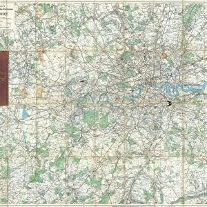
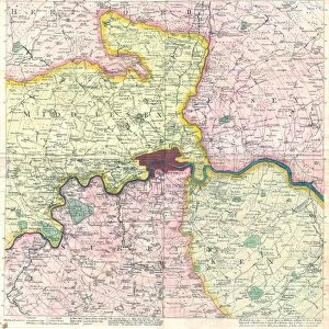
Map of Roman Kent, England, from A Short History of the English People by J

![]()
Wall Art and Photo Gifts from Fine Art Finder
Map of Roman Kent, England, from A Short History of the English People by J
KW392501 Map of Roman Kent, England, from A Short History of the English People by J. R. Green, published 1893 (litho) by English School, (19th century); Private Collection; Ken Welsh; English, out of copyright
Media ID 12871909
© www.bridgemanimages.com
County Diagram Essex Mapping Region South East Sussex Topographical Latin Names
EDITORS COMMENTS
This print showcases a fascinating piece of history - the Map of Roman Kent, England. Taken from J. R. Green's renowned book "A Short History of the English People" published in 1893, this lithographic masterpiece takes us back to ancient times. The intricate details and exquisite craftsmanship of this map transport us to the South East region of Britain during the Roman Empire era. With its Latin names and topographical representation, it offers a glimpse into the rich historical tapestry that once unfolded in Kent, Essex, Sussex, and beyond. As we study this remarkable illustration, we can't help but marvel at how it brings to life an empire that shaped not only England but also influenced countless nations across Europe. The map serves as a testament to the enduring legacy left by Ancient Rome on British soil. With every contour and boundary carefully delineated, this print allows us to explore the county's geography while immersing ourselves in its past. It is a visual time machine that transports us through centuries gone by. Whether you are an avid cartography enthusiast or simply intrigued by history's allure, this print is sure to captivate your imagination. Let it serve as a reminder that beneath our modern landscapes lie layers upon layers of stories waiting to be discovered and appreciated for generations to come.
MADE IN THE USA
Safe Shipping with 30 Day Money Back Guarantee
FREE PERSONALISATION*
We are proud to offer a range of customisation features including Personalised Captions, Color Filters and Picture Zoom Tools
SECURE PAYMENTS
We happily accept a wide range of payment options so you can pay for the things you need in the way that is most convenient for you
* Options may vary by product and licensing agreement. Zoomed Pictures can be adjusted in the Cart.