Jigsaw Puzzle > Maps and Charts > World
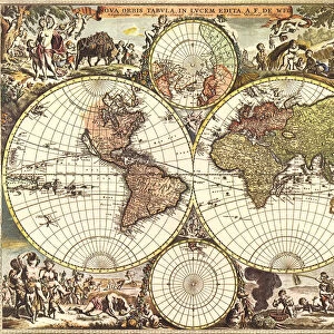
Jigsaw Puzzle : Double Hemisphere Map with Border 1611


![]()
Jigsaw Puzzles from Universal Images Group (UIG)
Double Hemisphere Map with Border 1611
Universal Images Group (UIG) manages distribution for many leading specialist agencies worldwide
Media ID 20165377
1611 Antiquarian Antiquarian Maps Border Cities Double Figures Globe Hemisphere Journeys Maps Nations Pairs Seven Showing Travels Treks Trip Trips Voyage Voyages Double Hemisphere Eighteen Fourteen Rulers
Jigsaw Puzzle (1014 Pieces)
Discover the wonders of geography with our Double Hemisphere Map with Border 1611 jigsaw puzzle from Media Storehouse and Universal Images Group (UIG) - PicturesNow. This captivating puzzle features an intricately detailed and historically significant map design. The Double Hemisphere Map, also known as the Orbis Terrarum, showcases the entire world as it was known in 1611. The map's elegant border adds an extra touch of sophistication and completes the puzzle's old-world charm. Assemble this jigsaw puzzle to expand your knowledge, improve problem-solving skills, and create a beautiful display piece for your home or office.
Made in the USA, 1014-piece puzzles measure 20" x 30" (50.8 x 76.2 cm). Every puzzle is meticulously printed on glossy photo paper, which has a strong 1.33 mm thickness. Delivered in a black storage cardboard box, these puzzles are both stylish and practical. (Note: puzzles contain small parts and are not suitable for children under 3 years of age.)
Jigsaw Puzzles are an ideal gift for any occasion
Estimated Product Size is 76cm x 50.8cm (29.9" x 20")
These are individually made so all sizes are approximate
Artwork printed orientated as per the preview above, with landscape (horizontal) orientation to match the source image.
FEATURES IN THESE COLLECTIONS
> Maps and Charts
> Related Images
> Maps and Charts
> World
> Universal Images Group (UIG)
> History
> Historical Maps
EDITORS COMMENTS
This print titled "Double Hemisphere Map with Border 1611" takes us on a mesmerizing journey back in time. Created in the year 1611, this antique map showcases the world as it was known centuries ago. The intricate border surrounding the double hemisphere design adds an extra layer of beauty and sophistication to this piece. As we delve into the details, we discover a wealth of information meticulously depicted on this map. From cities and nations to rulers and figures, every element tells a story of exploration and discovery. It is fascinating to see how our ancestors perceived the Earth's geography, with its eighteen pairs of hemispheres showcasing different parts of the globe. This artwork invites us to embark on imaginary voyages and treks across continents, reminding us of humanity's insatiable thirst for knowledge and adventure throughout history. It sparks curiosity about past civilizations' understanding of distant lands that were yet unexplored. The rich colors used in this print evoke a sense of nostalgia, transporting us back to an era when maps were not only functional but also works of art. This particular piece from Universal Images Group (UIG) captures the essence of antiquarian maps - their ability to educate while simultaneously enchanting viewers with their aesthetic appeal. Whether you are an avid traveler or simply fascinated by history, this Double Hemisphere Map will undoubtedly captivate your imagination as you explore ancient worlds through its carefully crafted details.
MADE IN THE USA
Safe Shipping with 30 Day Money Back Guarantee
FREE PERSONALISATION*
We are proud to offer a range of customisation features including Personalised Captions, Color Filters and Picture Zoom Tools
SECURE PAYMENTS
We happily accept a wide range of payment options so you can pay for the things you need in the way that is most convenient for you
* Options may vary by product and licensing agreement. Zoomed Pictures can be adjusted in the Cart.