Jigsaw Puzzle > Europe > United Kingdom > England > London > Sights > British Museum
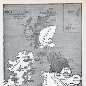
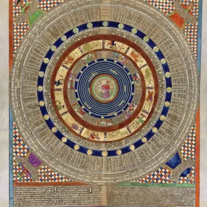
Jigsaw Puzzle : Anglo-Saxon map of 900s showing a flat earth and the ocean that was thought to surround it


![]()
Jigsaw Puzzles From Universal Images Group (UIG)
Anglo-Saxon map of 900s showing a flat earth and the ocean that was thought to surround it
Anglo-Saxon map of 900s showing a flat earth and the ocean that was thought to surround it. British Museum
Universal Images Group (UIG) manages distribution for many leading specialist agencies worldwide
Media ID 9782217
© Universal History Archive/Universal Images Group
Anglo Saxon Flat Museum Ocean Thought 900s Surround
Jigsaw Puzzle (520 Pieces)
Discover the rich history of cartography with our Anglo-Saxon Jigsaw Puzzle from Media Storehouse. This intriguing puzzle showcases an ancient map from the 900s, sourced from the British Museum. Depicting a flat earth model and the ocean believed to surround it during the Anglo-Saxon era, this puzzle is a captivating journey back in time. Challenge yourself and your family with this puzzle, perfect for history enthusiasts and puzzle lovers alike. Immerse yourself in the intricate details and bring the past to life piece by piece. Engaging, educational, and fun, this Anglo-Saxon puzzle is a must-have addition to your collection.
Made in the USA, 520-piece puzzles measure 16" x 20" (40.6 x 50.8 cm). Every puzzle is meticulously printed on glossy photo paper, which has a strong 1.33 mm thickness. Delivered in a black storage cardboard box, these puzzles are both stylish and practical. (Note: puzzles contain small parts and are not suitable for children under 3 years of age.)
Jigsaw Puzzles are an ideal gift for any occasion
Estimated Product Size is 50.8cm x 40.5cm (20" x 15.9")
These are individually made so all sizes are approximate
Artwork printed orientated as per the preview above, with landscape (horizontal) or portrait (vertical) orientation to match the source image.
FEATURES IN THESE COLLECTIONS
> Animals
> Fishes
> G
> Grouper
> Arts
> Artists
> O
> Oceanic Oceanic
> Europe
> United Kingdom
> England
> London
> Sights
> British Museum
> Maps and Charts
> Flat Earth
> Maps and Charts
> Related Images
EDITORS COMMENTS
This print from Universal Images Group (UIG) transports us back to the 900s, offering a glimpse into the fascinating world of Anglo-Saxon cartography. The image showcases an intricately crafted map that reveals the prevailing beliefs about the Earth's shape during that era. In this depiction, we witness a unique perspective as the Earth is portrayed as flat, with an expansive ocean encircling it. The attention to detail in this ancient map is truly remarkable. Delicate lines and intricate symbols trace out various regions and landmarks across the surface of this flattened Earth. It serves as a testament to the ingenuity and curiosity of our ancestors who sought to understand their surroundings despite limited knowledge and resources. What makes this particular piece even more intriguing is its historical context. This Anglo-Saxon map represents not only a visual representation but also offers insights into how people perceived their place in the world centuries ago. It serves as a reminder of how human understanding has evolved over time, shedding light on our progress in scientific exploration and discovery. Preserved within the esteemed British Museum, this artifact stands as a testament to both human imagination and intellectual growth throughout history. As we gaze upon this print, we are transported back in time—immersing ourselves in an era where maps were not just navigational tools but also windows into different cosmological beliefs held by past civilizations.
MADE IN THE USA
Safe Shipping with 30 Day Money Back Guarantee
FREE PERSONALISATION*
We are proud to offer a range of customisation features including Personalised Captions, Color Filters and Picture Zoom Tools
SECURE PAYMENTS
We happily accept a wide range of payment options so you can pay for the things you need in the way that is most convenient for you
* Options may vary by product and licensing agreement. Zoomed Pictures can be adjusted in the Basket.