Jigsaw Puzzle > Maps and Charts > Germany
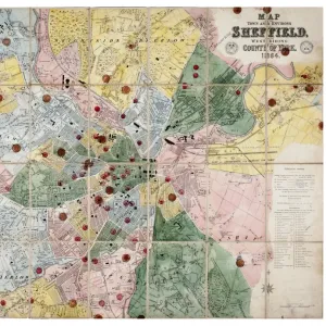
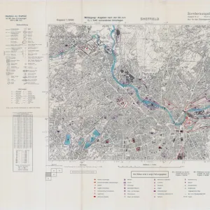
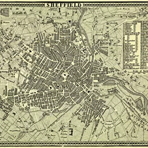
Jigsaw Puzzle : North Sheffield marked with bombing targets, c. 1940


![]()
Jigsaw Puzzles From Sheffield City Archives
North Sheffield marked with bombing targets, c. 1940
Full title: Ordnance Survey map of north Sheffield copied by the Germans, and marked with bombing targets, c. 1940
Original at Sheffield Libraries: y06718
Sheffield City Archives and Local Studies Library has an unrivalled collection of images of Sheffield, England
Media ID 14046831
© Sheffield City Council
Attercliffe Brightside Crookes Cyclops Grimesthorpe Maps Military Owlerton Park Reservoirs Second World War Steel Industry Walkley Works World War Two Wwii Bombs Hadfield Lower Shirecliffe
Jigsaw Puzzle (520 Pieces)
Discover the fascinating history of Sheffield during World War II with our unique jigsaw puzzle from Media Storehouse. This intriguing puzzle features an original Ordnance Survey map of North Sheffield, as it appeared during the war years, with bombing targets marked by the Germans around 1940. A captivating glimpse into the past, this jigsaw puzzle offers a stimulating challenge for puzzle enthusiasts and history buffs alike. Bring the past to life in the comfort of your own home and immerse yourself in the story of Sheffield's wartime history. Original map from Sheffield City Archives: y06718.
Made in the USA, 520-piece puzzles measure 16" x 20" (40.6 x 50.8 cm). Every puzzle is meticulously printed on glossy photo paper, which has a strong 1.33 mm thickness. Delivered in a black storage cardboard box, these puzzles are both stylish and practical. (Note: puzzles contain small parts and are not suitable for children under 3 years of age.)
Jigsaw Puzzles are an ideal gift for any occasion
Estimated Product Size is 50.8cm x 40.5cm (20" x 15.9")
These are individually made so all sizes are approximate
Artwork printed orientated as per the preview above, with landscape (horizontal) or portrait (vertical) orientation to match the source image.
FEATURES IN THESE COLLECTIONS
> Maps and Charts
> Related Images
> Maps and Charts
> World
> Sheffield City Archives
> Maps and Plans
> Maps of Sheffield
> Sheffield City Archives
> World War Two
EDITORS COMMENTS
This print showcases an extraordinary piece of history - a meticulously marked Ordnance Survey map of North Sheffield during the tumultuous times of World War II. Copied by the Germans around 1940, this map reveals their strategic bombing targets in the area. The image takes us back to a time when Sheffield's landscape was dotted with potential destruction, as indicated by these chilling markings. The city's resilience and importance during the war are evident in this snapshot, reminding us of its significant role in supporting Britain's steel industry and military efforts. From Hadfield Reservoirs to Crookes, Owlerton Park to Don Valley, Attercliffe to Brightside - every neighborhood is etched on this map with precision. It serves as a haunting reminder of how no corner was spared from potential devastation. Beyond its historical significance, this photograph also highlights the invaluable resources preserved at Sheffield Libraries. The original document (y06718) resides there today, safeguarding our collective memory and allowing us to delve into crucial moments like these. As we gaze upon this relic from the past, let us remember those who lived through such uncertain times and honor their strength and determination amidst adversity. May it serve as a poignant tribute to all those affected by war while inspiring gratitude for peace that prevails today.
MADE IN THE USA
Safe Shipping with 30 Day Money Back Guarantee
FREE PERSONALISATION*
We are proud to offer a range of customisation features including Personalised Captions, Color Filters and Picture Zoom Tools
SECURE PAYMENTS
We happily accept a wide range of payment options so you can pay for the things you need in the way that is most convenient for you
* Options may vary by product and licensing agreement. Zoomed Pictures can be adjusted in the Basket.