Jigsaw Puzzle > Historic > Ancient civilizations > Persia (Ancient Iran)
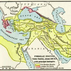
Jigsaw Puzzle : Extent of the Persian empire


![]()
Jigsaw Puzzles from North Wind
Extent of the Persian empire
Map of the ancient Persian empire.
Printed color lithograph of a 19th-century illustration
North Wind Picture Archives brings history to life with stock images and hand-colored illustrations
Media ID 5878221
© North Wind Picture Archives
Ancient Ancient City Ancient Civilization Ancient History Ancient Persia Antiquity Civilization Classical Classical Civilization Empire Iran Mid East Middle East Persia Persian Territory Persian Empire Persian Gulf
Jigsaw Puzzle (520 Pieces)
Discover the rich history and grandeur of the ancient world with Media Storehouse's Jigsaw Puzzle featuring the Extent of the Persian Empire from the North Wind Picture Archives. This intriguing puzzle showcases a captivating, colorful lithograph of a 19th-century illustration, providing a unique and engaging way to explore the vast territories of one of history's most influential civilizations. Challenge yourself or the whole family to piece together this intricate puzzle and learn about the fascinating history of the Persian Empire. Immerse yourself in the intricate details and beautiful colors of this historical masterpiece. Perfect for history enthusiasts, puzzle aficionados, or anyone seeking an enriching pastime.
Made in the USA, 520-piece puzzles measure 16" x 20" (40.6 x 50.8 cm). Every puzzle is meticulously printed on glossy photo paper, which has a strong 1.33 mm thickness. Delivered in a black storage cardboard box, these puzzles are both stylish and practical. (Note: puzzles contain small parts and are not suitable for children under 3 years of age.)
Jigsaw Puzzles are an ideal gift for any occasion
Estimated Product Size is 50.8cm x 40.5cm (20" x 15.9")
These are individually made so all sizes are approximate
Artwork printed orientated as per the preview above, with landscape (horizontal) or portrait (vertical) orientation to match the source image.
FEATURES IN THESE COLLECTIONS
> Asia
> Iran
> Related Images
> Historic
> Ancient civilizations
> Persia (Ancient Iran)
> Historic
> Ancient civilizations
> Maps and Charts
> Early Maps
> Maps and Charts
> Related Images
> North Wind Picture Archives
> Ancient history
> North Wind Picture Archives
> Maps
EDITORS COMMENTS
This print showcases the extensive reach of the Persian empire, offering a glimpse into the ancient world. The map, a printed color lithograph of a 19th-century illustration, beautifully captures the grandeur and vastness of this historic civilization. The vintage aesthetic adds an air of nostalgia to this classical depiction, transporting us back in time to an era filled with rich history and cultural significance. As we study the intricate details on this antiquated map, we are reminded of Iran's remarkable past as Persia – a land that was once home to one of the most powerful empires in human history. Stretching across territories that spanned from modern-day Iran all the way to parts of Egypt and Greece, this visual representation highlights not only Persia's territorial dominance but also its influence over neighboring regions. From bustling cities along the Persian Gulf to ancient architectural marvels scattered throughout its lands, there is no doubt that this empire left an indelible mark on our collective understanding of ancient civilizations. As we delve deeper into studying this mesmerizing artwork, it becomes evident why scholars continue to be fascinated by Persia's legacy. Its contributions to art, culture, science, and governance have shaped our modern world in countless ways. This print serves as a poignant reminder that even centuries later, we can still appreciate and learn from these great civilizations that once thrived in what is now known as the Middle East.
MADE IN THE USA
Safe Shipping with 30 Day Money Back Guarantee
FREE PERSONALISATION*
We are proud to offer a range of customisation features including Personalised Captions, Color Filters and Picture Zoom Tools
SECURE PAYMENTS
We happily accept a wide range of payment options so you can pay for the things you need in the way that is most convenient for you
* Options may vary by product and licensing agreement. Zoomed Pictures can be adjusted in the Cart.