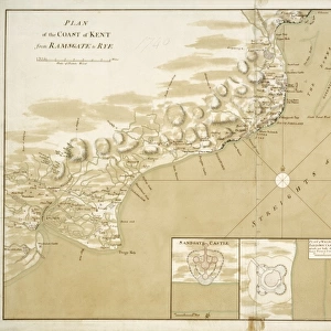
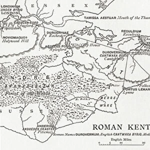
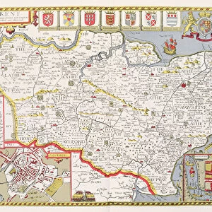
Jigsaw Puzzle : Map, County of Kent, 1839, 19th century engraving


![]()
Jigsaw Puzzles from Liszt Collection
Map, County of Kent, 1839, 19th century engraving
Liszt Collection of nineteenth-century engravings and images to browse and enjoy
Media ID 12808283
© Quint Lox Limited
Jigsaw Puzzle (520 Pieces)
Step back in time with our exquisite Jigsaw Puzzle from the Media Storehouse collection. This intriguing puzzle features a beautiful 19th century engraving of a map of Kent County, dating back to 1839. The intricate details of this antique map, sourced from the esteemed Liszt Collection, will transport you to a bygone era. Engage your mind and immerse yourself in the intricacies of this captivating puzzle, perfect for puzzle enthusiasts and history buffs alike. Experience the joy of discovery as you piece together the rich history and intricate details hidden within this timeless puzzle.
Made in the USA, 520-piece puzzles measure 16" x 20" (40.6 x 50.8 cm). Every puzzle is meticulously printed on glossy photo paper, which has a strong 1.33 mm thickness. Delivered in a black storage cardboard box, these puzzles are both stylish and practical. (Note: puzzles contain small parts and are not suitable for children under 3 years of age.)
Jigsaw Puzzles are an ideal gift for any occasion
Estimated Product Size is 40.5cm x 50.8cm (15.9" x 20")
These are individually made so all sizes are approximate
Artwork printed orientated as per the preview above, with landscape (horizontal) or portrait (vertical) orientation to match the source image.
EDITORS COMMENTS
This print showcases a remarkable piece of history, an engraving from the 19th century depicting the Map of County Kent in 1839. The Liszt Collection has beautifully preserved this exquisite artwork, allowing us to delve into the past and explore the intricate details of this significant region. The map itself is a testament to the artistry and precision of engravers during that era. Every line, contour, and landmark is meticulously etched onto paper, capturing the essence of County Kent with astonishing accuracy. From its charming towns to its sprawling countryside, this engraving offers a glimpse into what life was like in this corner of England nearly two centuries ago. As we study this map closely, we can trace our fingers along ancient roads and discover long-forgotten villages nestled amidst lush greenery. It serves as a visual time capsule that transports us back to an era when horse-drawn carriages traversed these very paths. Beyond its historical significance, this print also holds aesthetic appeal. The delicate engravings exude elegance and sophistication while evoking nostalgia for simpler times. Whether displayed in a home or office setting, it adds a touch of refinement while sparking conversations about both geography and heritage. The Liszt Collection's dedication to preserving such treasures ensures that future generations can appreciate not only the beauty but also gain insights into our rich cultural heritage through these extraordinary prints like "Map, County of Kent. "
MADE IN THE USA
Safe Shipping with 30 Day Money Back Guarantee
FREE PERSONALISATION*
We are proud to offer a range of customisation features including Personalised Captions, Color Filters and Picture Zoom Tools
SECURE PAYMENTS
We happily accept a wide range of payment options so you can pay for the things you need in the way that is most convenient for you
* Options may vary by product and licensing agreement. Zoomed Pictures can be adjusted in the Cart.