Jigsaw Puzzle > Maps and Charts > Related Images
Jigsaw Puzzle : Map of Asia 1896


![]()
Jigsaw Puzzles From Fine Art Storehouse
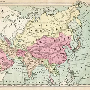
Map of Asia 1896
Andres Allgemeiner Handatlas - Bielefeld und Leipzig 1896
Unleash your creativity and transform your space into a visual masterpiece!
THEPALMER
Media ID 18356793
Jigsaw Puzzle (520 Pieces)
Discover the rich history of Asia with our captivating jigsaw puzzle from Media Storehouse. This intricately detailed puzzle features "Map of Asia 1896" by THEPALMER from Fine Art Storehouse, a rare and fascinating reproduction of the Andres Allgemeiner Handatlas published in Bielefeld and Leipzig in 1896. Immerse yourself in the intricacies of the map's borders, labels, and annotations, transporting you back in time as you piece together the complex geography of Asia. A perfect activity for history buffs, puzzle enthusiasts, or anyone seeking an engaging and educational experience. Engage your mind and uncover the mysteries of the past with Media Storehouse's Map of Asia 1896 jigsaw puzzle.
Made in the USA, 520-piece puzzles measure 16" x 20" (40.6 x 50.8 cm). Every puzzle is meticulously printed on glossy photo paper, which has a strong 1.33 mm thickness. Delivered in a black storage cardboard box, these puzzles are both stylish and practical. (Note: puzzles contain small parts and are not suitable for children under 3 years of age.)
Jigsaw Puzzles are an ideal gift for any occasion
Estimated Product Size is 50.8cm x 40.5cm (20" x 15.9")
These are individually made so all sizes are approximate
Artwork printed orientated as per the preview above, with landscape (horizontal) or portrait (vertical) orientation to match the source image.
EDITORS COMMENTS
This print showcases a remarkable piece of history, the "Map of Asia 1896" from Andres Allgemeiner Handatlas. Dating back to the late 19th century, this meticulously detailed map takes us on a journey through time, offering a glimpse into how Asia was perceived over a century ago. The intricate cartographic work is truly awe-inspiring, revealing the vastness and diversity of the Asian continent as it once stood. From the rugged terrains of Central Asia to the lush landscapes of Southeast Asia, every inch is beautifully illustrated with precision and artistry. As we delve deeper into this vintage masterpiece, we are transported back to an era when exploration and discovery were at their peak. The Map of Asia 1896 not only serves as an educational tool but also evokes a sense of nostalgia for those who appreciate historical artifacts. Expertly reproduced by THEPALMER for Fine Art Storehouse, this high-quality print captures every minute detail and color tone present in the original atlas. Its vibrant hues and exquisite craftsmanship make it an ideal addition to any art collection or study space. Whether you are an avid historian or simply fascinated by geography, this stunning print allows you to immerse yourself in an era long gone while appreciating the beauty that lies within ancient maps.
MADE IN THE USA
Safe Shipping with 30 Day Money Back Guarantee
FREE PERSONALISATION*
We are proud to offer a range of customisation features including Personalised Captions, Color Filters and Picture Zoom Tools
SECURE PAYMENTS
We happily accept a wide range of payment options so you can pay for the things you need in the way that is most convenient for you
* Options may vary by product and licensing agreement. Zoomed Pictures can be adjusted in the Basket.