Home > North America > United States of America > New York > New York > Maps
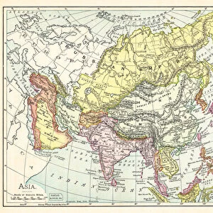
Asia map 1867

![]()
Wall Art and Photo Gifts from Fine Art Storehouse
Asia map 1867
Guyots Geographical Series The Earth and its inhabitants 1867 New York
Unleash your creativity and transform your space into a visual masterpiece!
THEPALMER
Media ID 14756946
© This content is subject to copyright
FEATURES IN THESE COLLECTIONS
> Asia
> Related Images
> Fine Art Storehouse
> Map
> Historical Maps
> Maps and Charts
> Early Maps
> North America
> United States of America
> New York
> New York
> Maps
EDITORS COMMENTS
This print titled "Asia map 1867" takes us on a journey back in time to the year when it was first published. Part of Guyot's Geographical Series, this particular piece is from the renowned book "The Earth and its Inhabitants" which was released in New York in 1867. With meticulous detail and artistic finesse, THEPALMER has skillfully captured this historical artifact, preserving its essence for generations to come. As we delve into the image, our eyes are immediately drawn to the intricate lines that define Asia's borders during this era. The map showcases an array of countries and territories with their names elegantly inscribed alongside them. It provides a fascinating glimpse into how political boundaries have evolved over time. The sepia tones used in this print add an air of nostalgia, enhancing its vintage charm. Each crease and worn edge tells a story of countless hands that have touched it throughout history. This photograph truly encapsulates the beauty found within aged maps – not only as functional tools but also as works of art that ignite curiosity about our world's past. Whether displayed in a study or living room, this remarkable piece invites viewers to embark on an intellectual voyage through time. It serves as a reminder of humanity's perpetual quest for knowledge and understanding of our planet's diverse landscapes and cultures. THEPALMER has masterfully transformed this antique map into a timeless work of art that will undoubtedly captivate any admirer seeking both aesthetic pleasure and historical enlightenment.
MADE IN THE USA
Safe Shipping with 30 Day Money Back Guarantee
FREE PERSONALISATION*
We are proud to offer a range of customisation features including Personalised Captions, Color Filters and Picture Zoom Tools
SECURE PAYMENTS
We happily accept a wide range of payment options so you can pay for the things you need in the way that is most convenient for you
* Options may vary by product and licensing agreement. Zoomed Pictures can be adjusted in the Cart.