Fine Art Print > Maps and Charts > Related Images
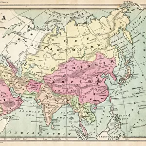
Fine Art Print : Map of Asia 1896


![]()
Fine Art Prints From Fine Art Storehouse
Map of Asia 1896
Andres Allgemeiner Handatlas - Bielefeld und Leipzig 1896
Unleash your creativity and transform your space into a visual masterpiece!
THEPALMER
Media ID 18356793
20"x16" (+3" Border) Fine Art Print
Discover the rich history and cultural diversity of Asia through the captivating lens of THEPALMER's Map of Asia, a stunning fine art print from our Media Storehouse collection. Originally published in Andres Allgemeiner Handatlas in 1896, this vintage map offers a fascinating glimpse into the political landscape of Asia during a pivotal period in world history. With intricate detail and vibrant colors, this fine art print makes a beautiful addition to any home or office, transporting you on a journey through time and geography. Bring a piece of historical cartography into your space and ignite your sense of adventure with Media Storehouse's Map of Asia 1896 by THEPALMER.
20x16 image printed on 26x22 Fine Art Rag Paper with 3" (76mm) white border. Our Fine Art Prints are printed on 300gsm 100% acid free, PH neutral paper with archival properties. This printing method is used by museums and art collections to exhibit photographs and art reproductions.
Our fine art prints are high-quality prints made using a paper called Photo Rag. This 100% cotton rag fibre paper is known for its exceptional image sharpness, rich colors, and high level of detail, making it a popular choice for professional photographers and artists. Photo rag paper is our clear recommendation for a fine art paper print. If you can afford to spend more on a higher quality paper, then Photo Rag is our clear recommendation for a fine art paper print.
Estimated Image Size (if not cropped) is 50.8cm x 40.6cm (20" x 16")
Estimated Product Size is 66cm x 55.9cm (26" x 22")
These are individually made so all sizes are approximate
Artwork printed orientated as per the preview above, with landscape (horizontal) orientation to match the source image.
FEATURES IN THESE COLLECTIONS
> Maps and Charts
> Related Images
> Fine Art Storehouse
> Map
> Historical Maps
EDITORS COMMENTS
This print showcases a remarkable piece of history, the "Map of Asia 1896" from Andres Allgemeiner Handatlas. Dating back to the late 19th century, this meticulously detailed map takes us on a journey through time, offering a glimpse into how Asia was perceived over a century ago. The intricate cartographic work is truly awe-inspiring, revealing the vastness and diversity of the Asian continent as it once stood. From the rugged terrains of Central Asia to the lush landscapes of Southeast Asia, every inch is beautifully illustrated with precision and artistry. As we delve deeper into this vintage masterpiece, we are transported back to an era when exploration and discovery were at their peak. The Map of Asia 1896 not only serves as an educational tool but also evokes a sense of nostalgia for those who appreciate historical artifacts. Expertly reproduced by THEPALMER for Fine Art Storehouse, this high-quality print captures every minute detail and color tone present in the original atlas. Its vibrant hues and exquisite craftsmanship make it an ideal addition to any art collection or study space. Whether you are an avid historian or simply fascinated by geography, this stunning print allows you to immerse yourself in an era long gone while appreciating the beauty that lies within ancient maps.
MADE IN THE USA
Safe Shipping with 30 Day Money Back Guarantee
FREE PERSONALISATION*
We are proud to offer a range of customisation features including Personalised Captions, Color Filters and Picture Zoom Tools
SECURE PAYMENTS
We happily accept a wide range of payment options so you can pay for the things you need in the way that is most convenient for you
* Options may vary by product and licensing agreement. Zoomed Pictures can be adjusted in the Basket.