Jigsaw Puzzle > Europe > Denmark > Maps
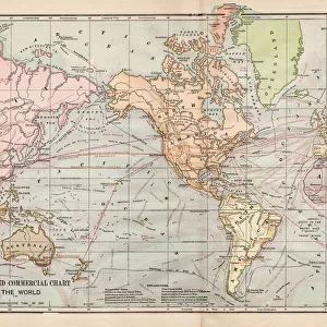
Jigsaw Puzzle : British, Dutch, French, Spanish, Portuguese, Italian, Danish colonies, lithograph, 1897


![]()
Jigsaw Puzzles from Fine Art Storehouse
British, Dutch, French, Spanish, Portuguese, Italian, Danish colonies, lithograph, 1897
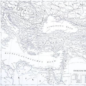
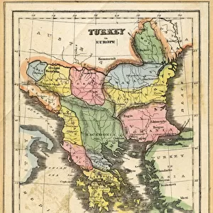
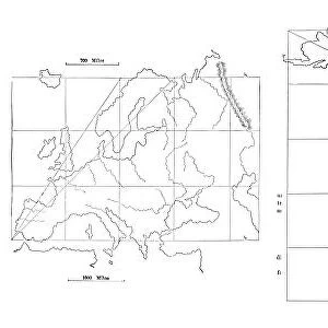
British, Dutch, French, Spanish, Portuguese, Italian and Danish colonies at the end of the 19th century. Lithograph, published in 1897
Unleash your creativity and transform your space into a visual masterpiece!
Media ID 15372241
© This content is subject to copyright
America Australia British Culture Colonialism Colony Country Danish Culture Dutch Culture English Culture European Culture French Culture Italian Culture North America Portuguese Culture South America Spanish Culture World Map Yellow Imperialism Multi Colored White Color
Jigsaw Puzzle (520 Pieces)
Step back in time with our exquisite collection of jigsaw puzzles from Media Storehouse, featuring a captivating lithograph of European colonies from 1897. Explore the rich history of British, Dutch, French, Spanish, Portuguese, Italian, and Danish territories as depicted in this intricately detailed image. Perfect for history buffs and puzzle enthusiasts alike, this challenging yet rewarding puzzle promises an engaging experience for all ages. Immerse yourself in the past and bring this piece of history to life, one piece at a time.
Made in the USA, 520-piece puzzles measure 16" x 20" (40.6 x 50.8 cm). Every puzzle is meticulously printed on glossy photo paper, which has a strong 1.33 mm thickness. Delivered in a black storage cardboard box, these puzzles are both stylish and practical. (Note: puzzles contain small parts and are not suitable for children under 3 years of age.)
Jigsaw Puzzles are an ideal gift for any occasion
Estimated Product Size is 40.5cm x 50.8cm (15.9" x 20")
These are individually made so all sizes are approximate
Artwork printed orientated as per the preview above, with landscape (horizontal) or portrait (vertical) orientation to match the source image.
FEATURES IN THESE COLLECTIONS
> Fine Art Storehouse
> Map
> Historical Maps
> Africa
> Related Images
> Africa
> South Africa
> Maps
> Africa
> South Africa
> Related Images
> Asia
> Related Images
> Europe
> Denmark
> Related Images
EDITORS COMMENTS
This lithograph from 1897 offers a vivid glimpse into the extensive colonial empires of Britain, the Netherlands, France, Spain, Portugal, Italy, and Denmark at the close of the 19th century. The intricate map showcases these European powers' dominions across various continents – Europe itself as well as Africa, America (both North and South), Asia, and Australia. With its vibrant yellow background juxtaposed with white and multi-colored details, this print is not only historically significant but also visually striking. As we delve into this piece's historical context, it becomes apparent that it represents an era defined by imperialism and colonialism. It serves as a reminder of how these nations sought to expand their influence globally during this period in history. Each color on the map signifies a different country's territory or sphere of influence within their respective colonies. The engraving technique used in creating this lithograph adds depth and texture to the image while maintaining its overall clarity. Its vertical orientation allows for easy appreciation of each region's boundaries and geographical features. This remarkable artwork transports us back in time to witness firsthand the vast extent of European colonial power at its zenith. It invites contemplation on themes such as national identity, cultural exchange between colonizers and indigenous peoples, geopolitical rivalries among European powers themselves – all within a historical framework that shaped our modern world.
MADE IN THE USA
Safe Shipping with 30 Day Money Back Guarantee
FREE PERSONALISATION*
We are proud to offer a range of customisation features including Personalised Captions, Color Filters and Picture Zoom Tools
SECURE PAYMENTS
We happily accept a wide range of payment options so you can pay for the things you need in the way that is most convenient for you
* Options may vary by product and licensing agreement. Zoomed Pictures can be adjusted in the Cart.