Fine Art Print > Europe > Denmark > Maps
Fine Art Print : British, Dutch, French, Spanish, Portuguese, Italian, Danish colonies, lithograph, 1897


![]()
Fine Art Prints from Fine Art Storehouse
British, Dutch, French, Spanish, Portuguese, Italian, Danish colonies, lithograph, 1897
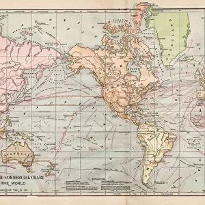
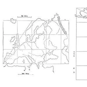
British, Dutch, French, Spanish, Portuguese, Italian and Danish colonies at the end of the 19th century. Lithograph, published in 1897
Unleash your creativity and transform your space into a visual masterpiece!
Media ID 15372241
© This content is subject to copyright
America Australia British Culture Colonialism Colony Country Danish Culture Dutch Culture English Culture European Culture French Culture Italian Culture North America Portuguese Culture South America Spanish Culture World Map Yellow Imperialism Multi Colored White Color
20"x16" (+3" Border) Fine Art Print
Step back in time with our exquisite selection of Fine Art Prints from Media Storehouse. This captivating lithograph, published in 1897, transports you to the late 19th century as it showcases the British, Dutch, French, Spanish, Portuguese, Italian, and Danish colonies in stunning detail. Each intricately drawn image offers a glimpse into the rich history and cultural diversity of this era. Bring the elegance and sophistication of this bygone era into your home or office and add a touch of timeless beauty to your space.
20x16 image printed on 26x22 Fine Art Rag Paper with 3" (76mm) white border. Our Fine Art Prints are printed on 300gsm 100% acid free, PH neutral paper with archival properties. This printing method is used by museums and art collections to exhibit photographs and art reproductions.
Our fine art prints are high-quality prints made using a paper called Photo Rag. This 100% cotton rag fibre paper is known for its exceptional image sharpness, rich colors, and high level of detail, making it a popular choice for professional photographers and artists. Photo rag paper is our clear recommendation for a fine art paper print. If you can afford to spend more on a higher quality paper, then Photo Rag is our clear recommendation for a fine art paper print.
Estimated Image Size (if not cropped) is 40.6cm x 49cm (16" x 19.3")
Estimated Product Size is 55.9cm x 66cm (22" x 26")
These are individually made so all sizes are approximate
Artwork printed orientated as per the preview above, with portrait (vertical) orientation to match the source image.
FEATURES IN THESE COLLECTIONS
> Africa
> Related Images
> Africa
> South Africa
> Maps
> Africa
> South Africa
> Related Images
> Asia
> Related Images
> Europe
> Denmark
> Related Images
> Fine Art Storehouse
> Map
> Historical Maps
EDITORS COMMENTS
This lithograph from 1897 offers a vivid glimpse into the extensive colonial empires of Britain, the Netherlands, France, Spain, Portugal, Italy, and Denmark at the close of the 19th century. The intricate map showcases these European powers' dominions across various continents – Europe itself as well as Africa, America (both North and South), Asia, and Australia. With its vibrant yellow background juxtaposed with white and multi-colored details, this print is not only historically significant but also visually striking. As we delve into this piece's historical context, it becomes apparent that it represents an era defined by imperialism and colonialism. It serves as a reminder of how these nations sought to expand their influence globally during this period in history. Each color on the map signifies a different country's territory or sphere of influence within their respective colonies. The engraving technique used in creating this lithograph adds depth and texture to the image while maintaining its overall clarity. Its vertical orientation allows for easy appreciation of each region's boundaries and geographical features. This remarkable artwork transports us back in time to witness firsthand the vast extent of European colonial power at its zenith. It invites contemplation on themes such as national identity, cultural exchange between colonizers and indigenous peoples, geopolitical rivalries among European powers themselves – all within a historical framework that shaped our modern world.
MADE IN THE USA
Safe Shipping with 30 Day Money Back Guarantee
FREE PERSONALISATION*
We are proud to offer a range of customisation features including Personalised Captions, Color Filters and Picture Zoom Tools
SECURE PAYMENTS
We happily accept a wide range of payment options so you can pay for the things you need in the way that is most convenient for you
* Options may vary by product and licensing agreement. Zoomed Pictures can be adjusted in the Cart.