Jigsaw Puzzle > Europe > United Kingdom > Scotland > Maps
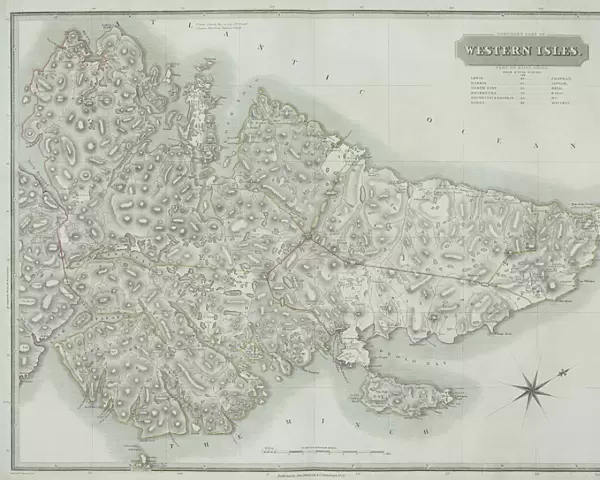
Jigsaw Puzzle : Antique map of the Western Isles off Scotland
![]()

Jigsaw Puzzles from Fine Art Storehouse
Antique map of the Western Isles off Scotland
antique, archival, border, cartography, coordinates, document, geography, historical, island, key, latitude, legend, longitude, map, nobody, orientation, outer hebrides, scale, scotland, uk, united kingdom, vintage, western isles, Antique Maps, 87648305
Unleash your creativity and transform your space into a visual masterpiece!
Hemera Technologies
Media ID 25128185
© Getty Images
Border Coordinates Document Geography Island Latitude Legend Longitude Orientation Outer Hebrides Scale Scotland United Kingdom Western Isles
Jigsaw Puzzle (520 Pieces)
Step back in time with our Antique Map of the Western Isles off Scotland from Media Storehouse's Fine Art Storehouse collection. This intricately detailed jigsaw puzzle showcases an historical document of geographical importance, featuring the outer Hebrides and their surrounding waters. The map, filled with archival cartography, includes key coordinates, latitude and longitude markings, a legend, and an orientation guide. Immerse yourself in the rich history of Scotland and the UK as you piece together this beautiful puzzle, perfect for collectors, enthusiasts, and anyone who appreciates the art of cartography.
Made in the USA, 520-piece puzzles measure 16" x 20" (40.6 x 50.8 cm). Every puzzle is meticulously printed on glossy photo paper, which has a strong 1.33 mm thickness. Delivered in a black storage cardboard box, these puzzles are both stylish and practical. (Note: puzzles contain small parts and are not suitable for children under 3 years of age.)
Jigsaw Puzzles are an ideal gift for any occasion
Estimated Product Size is 50.8cm x 40.5cm (20" x 15.9")
These are individually made so all sizes are approximate
Artwork printed orientated as per the preview above, with landscape (horizontal) or portrait (vertical) orientation to match the source image.
FEATURES IN THESE COLLECTIONS
> Fine Art Storehouse
> Map
> Historical Maps
> Animals
> Mammals
> Muridae
> Western Mouse
> Europe
> United Kingdom
> Maps
> Europe
> United Kingdom
> Related Images
> Europe
> United Kingdom
> Scotland
> Maps
> Europe
> United Kingdom
> Scotland
> Posters
> Europe
> United Kingdom
> Scotland
> Related Images
> Europe
> United Kingdom
> Scotland
> Scottish Borders
> Related Images
> Europe
> United Kingdom
> Scotland
> Western Isles
> Related Images
> Maps and Charts
> Early Maps
> Maps and Charts
> Related Images
EDITORS COMMENTS
This antique map of the Western Isles off Scotland takes us on a journey through time and geography. Printed on high-quality archival paper, this vintage piece showcases the intricate details and craftsmanship of traditional cartography. The map's border is adorned with delicate designs, adding an elegant touch to its historical significance. Its precise coordinates, latitude, and longitude markings provide a valuable resource for explorers and historians alike. The legend and key offer further insight into the unique features of these enchanting islands. With its orientation perfectly aligned, this document transports us to the Outer Hebrides in Scotland. From Barra in the south to Lewis in the north, each island is meticulously depicted with accuracy and scale. This print allows you to immerse yourself in the rich history that surrounds these ancient lands. As we gaze upon this remarkable artwork, we are reminded of Scotland's enduring beauty and cultural heritage. The United Kingdom's westernmost region comes alive through this antique map - a testament to Hemera Technologies' commitment to preserving our past. Whether displayed as a centerpiece or part of a collection, this antique map serves as both an educational tool and a stunning piece of art. Let it transport you back in time as you explore the Western Isles from your own home – truly an invaluable addition for any history enthusiast or lover of fine art.
MADE IN THE USA
Safe Shipping with 30 Day Money Back Guarantee
FREE PERSONALISATION*
We are proud to offer a range of customisation features including Personalised Captions, Color Filters and Picture Zoom Tools
SECURE PAYMENTS
We happily accept a wide range of payment options so you can pay for the things you need in the way that is most convenient for you
* Options may vary by product and licensing agreement. Zoomed Pictures can be adjusted in the Cart.


