Jigsaw Puzzle > Africa > Egypt > Maps
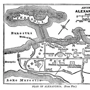
Jigsaw Puzzle : Map Of Ancient Alexandria, Egypt. From The Imperial Bible Dictionary, Published 1889


![]()
Jigsaw Puzzles from Design Pics
Map Of Ancient Alexandria, Egypt. From The Imperial Bible Dictionary, Published 1889
Design Pics offers Distinctively Different Imagery representing over 1,500 contributors
Media ID 18200629
© Ken Welsh / Design Pics
Alexandria Ancient Chart Egypt Egyptian Geographical Geography Mapmaking
Jigsaw Puzzle (520 Pieces)
Discover the mysteries of ancient history with our exquisite jigsaw puzzle from the Media Storehouse collection. This intriguing puzzle features a captivating map of Ancient Alexandria, Egypt, taken from The Imperial Bible Dictionary, published in 1889. Bring the past to life as you piece together this detailed and captivating image by renowned photographer Ken Welsh from Design Pics. Immerse yourself in the rich history of one of the greatest cities of the ancient world, and enjoy the satisfaction of completing a high-quality jigsaw puzzle that is sure to be a conversation starter in your home.
Made in the USA, 520-piece puzzles measure 16" x 20" (40.6 x 50.8 cm). Every puzzle is meticulously printed on glossy photo paper, which has a strong 1.33 mm thickness. Delivered in a black storage cardboard box, these puzzles are both stylish and practical. (Note: puzzles contain small parts and are not suitable for children under 3 years of age.)
Jigsaw Puzzles are an ideal gift for any occasion
Estimated Product Size is 50.8cm x 40.5cm (20" x 15.9")
These are individually made so all sizes are approximate
Artwork printed orientated as per the preview above, with landscape (horizontal) or portrait (vertical) orientation to match the source image.
FEATURES IN THESE COLLECTIONS
> Africa
> Egypt
> Alexandria
> Africa
> Egypt
> Related Images
> Maps and Charts
> Early Maps
> Maps and Charts
> Related Images
EDITORS COMMENTS
This print showcases a remarkable piece of history - the Map of Ancient Alexandria, Egypt. Published in 1889 as part of the Imperial Bible Dictionary, this map takes us back to a time when this legendary city was at its zenith. With intricate details and meticulous craftsmanship, it offers a glimpse into the geographical landscape and rich cultural heritage of ancient Egypt. The map's faded hues evoke a sense of nostalgia, transporting us to an era long gone. It highlights the strategic location of Alexandria on the Mediterranean coast, with its bustling harbor serving as a gateway for trade and cultural exchange. The city's grandeur is depicted through its labyrinthine streets, majestic palaces, and iconic landmarks such as the Pharos Lighthouse - one of the Seven Wonders of the Ancient World. As we delve into this historical artifact created by Ken Welsh, we are reminded that maps not only serve practical purposes but also hold immense storytelling power. They unravel tales from distant lands and connect us to our roots. This particular map serves as an invaluable resource for scholars studying ancient civilizations or enthusiasts seeking to explore Alexandria's past. Whether you're fascinated by cartography or simply drawn to Egypt's enchanting history, this print will transport you back in time and ignite your imagination. Let it be a window into an extraordinary world that once thrived along the banks of the Nile River – Ancient Alexandria awaits your exploration!
MADE IN THE USA
Safe Shipping with 30 Day Money Back Guarantee
FREE PERSONALISATION*
We are proud to offer a range of customisation features including Personalised Captions, Color Filters and Picture Zoom Tools
SECURE PAYMENTS
We happily accept a wide range of payment options so you can pay for the things you need in the way that is most convenient for you
* Options may vary by product and licensing agreement. Zoomed Pictures can be adjusted in the Cart.