Jigsaw Puzzle > Maps and Charts > World
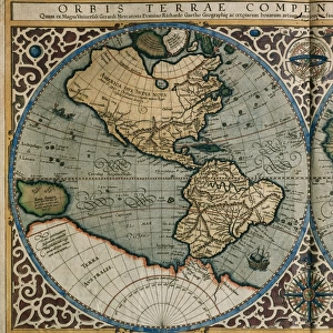
Jigsaw Puzzle : Map of the world by Gerard Mercator, first published circa 1595. Orbis terrae compendiosa descriptio


![]()
Jigsaw Puzzles From Design Pics
Map of the world by Gerard Mercator, first published circa 1595. Orbis terrae compendiosa descriptio
Design Pics offers Distinctively Different Imagery representing over 1,500 contributors
Media ID 24904004
© Ken Welsh / Design Pics
16th Century Cartography Countries Décor Decoration Decorative Geographical Geography Wall Art World Double Hemisphere Gerard Mercator Map Making
Jigsaw Puzzle (520 Pieces)
Discover the wonders of the world with our exquisite Jigsaw Puzzles from Media Storehouse. Our collection includes this stunning vintage map, "Orbis terrae compendiosa descriptio," first published by renowned cartographer Gerard Mercator around 1595. This intricately detailed puzzle features Mercator's iconic representation of the world, showcasing the known continents, islands, and waterways during the late Renaissance era. Immerse yourself in history, geography, and puzzle-solving fun as you piece together this beautiful puzzle. Perfect for families, educators, and collectors alike, our high-quality puzzles promise hours of entertainment and a rewarding experience. Bring history to life in your home!
Made in the USA, 520-piece puzzles measure 16" x 20" (40.6 x 50.8 cm). Every puzzle is meticulously printed on glossy photo paper, which has a strong 1.33 mm thickness. Delivered in a black storage cardboard box, these puzzles are both stylish and practical. (Note: puzzles contain small parts and are not suitable for children under 3 years of age.)
Jigsaw Puzzles are an ideal gift for any occasion
Estimated Product Size is 50.8cm x 40.5cm (20" x 15.9")
These are individually made so all sizes are approximate
Artwork printed orientated as per the preview above, with landscape (horizontal) or portrait (vertical) orientation to match the source image.
FEATURES IN THESE COLLECTIONS
> Maps and Charts
> Early Maps
> Maps and Charts
> World
EDITORS COMMENTS
This stunning print showcases the remarkable "Map of the world by Gerard Mercator" a masterpiece first published circa 1595. Known as Orbis terrae compendiosa descriptio, this map is a true testament to Mercator's skill and artistry in cartography. With its vibrant colors and intricate details, this illustration transports us back to the 16th century, offering a glimpse into the geographical and historical knowledge of that era. The double hemisphere design allows us to explore different continents and countries, providing an invaluable snapshot of how our world was perceived at that time. The Welsh artist Ken has beautifully captured every aspect of this old-world map, making it an ideal choice for wall art or decorative purposes. Its rich hues and fine craftsmanship add elegance and sophistication to any space. Whether you're a history enthusiast or simply appreciate the beauty of vintage maps, this print is sure to captivate your imagination. It serves as a reminder of how far we've come in terms of geography while honoring the legacy left behind by Gerard Mercator – one of history's most influential figures in map-making
MADE IN THE USA
Safe Shipping with 30 Day Money Back Guarantee
FREE PERSONALISATION*
We are proud to offer a range of customisation features including Personalised Captions, Color Filters and Picture Zoom Tools
SECURE PAYMENTS
We happily accept a wide range of payment options so you can pay for the things you need in the way that is most convenient for you
* Options may vary by product and licensing agreement. Zoomed Pictures can be adjusted in the Basket.