Fraud Blocker Skip to main content

Home > Arts > Artists > M > Gerardus Mercator

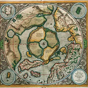
Atlas of Gerardus Mercator, 1595, map of the Arctic to the North Pole and surrounding

Atlas of Gerardus Mercator, 1595, map of the Arctic to the North Pole and surrounding
Sold 3
In Stock
We accept all major credit cards

Heritage Images Photo Prints and Wall Art

Atlas of Gerardus Mercator, 1595, map of the Arctic to the North Pole and surrounding

Atlas of Gerardus Mercator, 1595, map of the Arctic to the North Pole and surrounding lands within and outside the Arctic Circle. Heritage Images features heritage image collections. © Mithra - Index / Heritage-Images

Media ID 15196340

Arctic Atlas Circle Gerardus Maps Mercator North Pole Polar Surrounding Gerardo Lands Santiago Ortega

FEATURES IN THESE COLLECTIONS

> Arts > Artists > M > Gerardus Mercator

> Maps and Charts > Gerardus Mercator's Cartographic

> Maps and Charts > Related Images

SECURE PAYMENTS
We happily accept a wide range of payment options so you can pay for the things you need in the way that is most convenient for you

MADE IN THE USA
Safe Shipping with 30 Day Money Back Guarantee

FREE PERSONALISATION
We are proud to offer a range of customisation including Cropping, Captions, and Filters. Zoom Cropping can be adjusted in the Basket.


EDITORS COMMENTS

This print showcases the remarkable "Atlas of Gerardus Mercator" from 1595, featuring a meticulously detailed map of the Arctic region. Created by the renowned cartographer Gerardus Mercator (1512-1594), this historic atlas offers a fascinating glimpse into the world as it was perceived during the 16th century. The map itself encompasses not only the Arctic Circle but also extends to include lands both within and outside its boundaries. With vibrant colors and intricate design, this horizontal depiction presents an extraordinary level of accuracy for its time. It serves as a testament to Mercator's exceptional skill in cartography and his dedication to capturing geographical knowledge. As we gaze upon this ancient artifact, our eyes are drawn towards the North Pole at its center, surrounded by vast icy landscapes that have long fascinated explorers and adventurers alike. The attention to detail is awe-inspiring, with every contour of land carefully illustrated alongside bodies of water. This particular print has been expertly captured by Santiago Ortega, ensuring that every nuance and hue is faithfully preserved. While it should be noted that commercial use is prohibited for this image, one cannot deny its immense historical value and aesthetic appeal. Whether you are an avid collector or simply appreciate artistry from centuries past, this stunning print invites you on a visual journey through time – allowing you to marvel at Mercator's genius while exploring uncharted territories in your imagination.


Framed Prints

Introducing the Media Storehouse Framed Prints featuring the iconic "Atlas of Gerardus Mercator, 1595," a masterpiece of cartography that has stood the test of time. This exquisite print showcases the Arctic region, extending from the Arctic Circle to the North Pole, and the lands surrounding it. With intricate details and vivid colors, this historic map brings the wonders of the Arctic world into your home or office. Each Framed Print is meticulously crafted with a high-quality matte finish and a sturdy frame, ensuring your investment is both a visual delight and a lasting addition to your collection. Transport yourself to a bygone era with the Media Storehouse Framed Print of Gerardus Mercator's legendary atlas.


Photo Prints

Discover the captivating beauty of the past with our Media Storehouse range of Photographic Prints featuring the iconic "Atlas of Gerardus Mercator, 1595" map of the Arctic and the North Pole. This exquisite vintage print showcases intricate details of the Arctic region as it was once understood, with an enchanting depiction of the mysterious North Pole and the lands surrounding it. Journey back in time and adorn your home or office with this historical masterpiece, a perfect blend of art and cartography. Experience the allure of the unknown and expand your knowledge with our high-quality photographic prints.


Poster Prints

Discover the fascinating world of exploration and cartography with our Media Storehouse range of Poster Prints featuring the iconic "Atlas of Gerardus Mercator, 1595." This captivating map transports you back in time, showcasing the Arctic region and its surrounding lands as they were perceived during the late 16th century. Gerardus Mercator's masterpiece meticulously illustrates the Arctic Circle, the North Pole, and the lands beyond, including Greenland, Norway, Russia, and the North American continent. The intricate detailing and vivid colors bring the historical map to life, making it an essential addition to any home or office. Our high-quality poster prints are produced using premium materials to ensure lasting brilliance and vibrancy. Experience the rich history of cartography and expand your knowledge of the world with this captivating piece of art. Bring the mysteries of the Arctic to your space and ignite the spirit of adventure within.


Jigsaw Puzzles

Discover the wonders of the historic world with Media Storehouse's exquisite jigsaw puzzle of the "Atlas of Gerardus Mercator, 1595." This intriguing puzzle showcases a captivating map of the Arctic, extending to the North Pole and the surrounding lands. Journey back in time as you piece together this detailed representation of the world as it was understood during the late Renaissance period. Explore the vast Arctic expanse and uncover the mysteries hidden within the intricate borders of this beautiful puzzle. A perfect addition to any home or office, this challenging and rewarding puzzle is sure to inspire curiosity and delight.

diamond
Made With High Grade Materials
thumb_up
Professional Quality Finish
package_2
Carefully Packed To Aid Safe Arrival

You May Also Like


Post WWII, FA 40454sPost WWII, FA 40454s
Add to Basket
Madagascar, Aerial view of Antananarivo Stadium and Lake Anosy with war memorialMadagascar, Aerial view of Antananarivo Stadium and Lake Anosy with war memorial
Add to Basket
Rubans de Paris - Corner of Maddox Street / St George StreetRubans de Paris - Corner of Maddox Street / St George Street
Add to Basket
Ensemble, c. 1730 (wool, silk & metallic thread)Ensemble, c. 1730 (wool, silk & metallic thread)
Add to Basket
Angel Falls VenezuelaAngel Falls Venezuela
Add to Basket
Cessna CitationCessna Citation
Add to Basket
Cessna 172 Cutaway DrawingCessna 172 Cutaway Drawing
Add to Basket
Queen Pornare, Tahiti, Society IslandsQueen Pornare, Tahiti, Society Islands
Add to Basket
Tabarin. Dancer at the Tabarin nightclub in Montmartre, Paris. Oil on canvas, 1905, by Georges RouaultTabarin. Dancer at the Tabarin nightclub in Montmartre, Paris. Oil on canvas, 1905, by Georges Rouault
Add to Basket
Puerto Rico, Carolina, silhouettes of people walking along beach at Isla Verde, sunsetPuerto Rico, Carolina, silhouettes of people walking along beach at Isla Verde, sunset
Add to Basket
The Death of Socrates (470-499 BC) 1762 (oil on canvas) (b / w photo)The Death of Socrates (470-499 BC) 1762 (oil on canvas) (b / w photo)
Add to Basket
Asia, South Korea, Taegu. Detail of a wall mural at a Buddhist Temple. Credit asAsia, South Korea, Taegu. Detail of a wall mural at a Buddhist Temple. Credit as
Add to Basket

Gallery Wall Inspiration

17th century map of the New World
17th century map of Europe
Portrait of Gerhard Kremer dit Gerardus Mercator (1512-1594)
Mercator, (1512-1594), 1830. Creator: Unknown
Atlas of Gerardus Mercator, 1595, map of the Arctic to the North Pole and surrounding
Septentrionalium Terrarum descriptio, 1595, by Gerardus Merc
16th century map of the British Isles
17th century map of the New World
17th century map of South America
Atlas of Gerardus Mercator, 1595. World Map
JAPAN: MAP, 1606. Map of Japan engraved by Jodocus Hondius for a 1606 edition of Gerardus Mercators Atlas. Korea is shown as an island
Atlas 1587: Orbis Terrae Compendiosa Descriptio de Rumold Mercator (1546 / 48-1599), third son of Gerhard Kremer, known as Gerardus Mercator
Islandia, Per Gerardum Mercatorem cum privilegio, c.1595 (ink, watercolour, engraving, paper)
Engraving depicting Gerardus Mercator and Jodocus Hondius
Terrestrial Globe, detail of the Pacific Ocean with a large pair of dividers, 1541 (papier mache, plaster, ink, varnish, brass, wood, cloth, paper, lead, engraved)
Theatrum Orbis Terrarium, 1592. Creator: Unknown
Mercator and Ortelius (oil on canvas)
Mexico (engraving, 1596)
Japan (engraving, 1596)
Iraq and Afghanistan (engraving, 1596)
North Africa with siege of Tunis and Nile delta (engraving, 1596)
Africa (engraving, 1596)
Macedonia and Greece (engraving, 1596)
Corsica, France (engraving, 1596)
Piemond, Genoa and Montserrat (engraving, 1596)
Italy (engraving, 1596)
Moravia, Czech Republic (engraving, 1596)

Discover Our Collections


Gerardus MercatorGerardus Mercator
View Collection
Maps and Charts Related ImagesMaps and Charts Related Images
View Collection
Gerardus Mercator's Cartographic LegacyGerardus Mercator's Cartographic Legacy
View Collection


© Copyright Media Storehouse, All Rights Reserved 2003 - 2024
Facebook     Pinterest     Card Payments     Reviews IO