Home > Africa > Madagascar > Maps
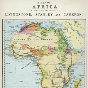
'Bathymetrie de l'Ouest de l'Ocean Indien; Iles Africaines de la mer des Indes, 1914. Creator: Unknown

![]()
Wall Art and Photo Gifts from Heritage Images
'Bathymetrie de l'Ouest de l'Ocean Indien; Iles Africaines de la mer des Indes, 1914. Creator: Unknown
'Bathymetrie de l'Ouest de l'Ocean Indien; Iles Africaines de la mer des Indes, 1914. From "Grande Geographie Bong Illustree", 1914
Heritage Images features heritage image collections
Media ID 36287268
© The Print Collector/Heritage Images
Cartography Geological Map Madagascar Map Making Mapmaking
FEATURES IN THESE COLLECTIONS
> Africa
> Madagascar
> Maps
> Africa
> Madagascar
> Related Images
> Maps and Charts
> Geological Map
Bathymetrie de l'Ouest de l'Ocean Indien; Iles Africaines de la Mer des Indes
EDITORS COMMENTS
is an intriguing and historically significant geographical map print from the early 20th century. The map, created in 1914, depicts the western part of the Indian Ocean and the African islands in that region. The map's title translates to "Bathymetry of the West of the Indian Ocean; African Islands of the Indian Sea" in English. The map is a testament to the advancements in cartography and geological exploration during the 1900s. The use of color and detail in the map is striking, with various shades representing the depths of the ocean floor. The map also includes labels for numerous islands and countries in the region, including Madagascar, Mauritius, Reunion, and Mayotte. The map was published in "Grande Geographie Bong Illustree," a French geography magazine, in 1914. Despite the lack of information regarding the creator of the map itself, it is clear that this was an important piece of cartographic work produced during a time when European powers were expanding their influence and knowledge of the world's oceans and continents. The map provides a fascinating glimpse into the geographical knowledge of the African continent and the Indian Ocean during the early 20th century. Its intricate detail and use of color make it a visually stunning addition to any collection of historical maps or geographical prints. Whether used for educational or decorative purposes, this map is a valuable reminder of the rich history of cartography and the exploration of the world's oceans and continents.
MADE IN THE USA
Safe Shipping with 30 Day Money Back Guarantee
FREE PERSONALISATION*
We are proud to offer a range of customisation features including Personalised Captions, Color Filters and Picture Zoom Tools
SECURE PAYMENTS
We happily accept a wide range of payment options so you can pay for the things you need in the way that is most convenient for you
* Options may vary by product and licensing agreement. Zoomed Pictures can be adjusted in the Cart.