Home > Arts > Artists > S > John Speed
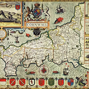
NEW WORLD MAP, 1616. English map of the western hemisphere published by John Speed in 1616

![]()
Wall Art and Photo Gifts from Granger
NEW WORLD MAP, 1616. English map of the western hemisphere published by John Speed in 1616
NEW WORLD MAP, 1616. English map of the western hemisphere published by John Speed in 1616. California appears as a huge island and the views along both sides are of natives in fanciful costumes
Granger holds millions of images spanning more than 25,000 years of world history, from before the Stone Age to the dawn of the Space Age
Media ID 6622233
1616 Age Of Discovery Atlantic Ocean California Colony New World Pacific Ocean Settlement South America South Pacific Speed Western Hemisphere World
FEATURES IN THESE COLLECTIONS
> Arts
> Artists
> S
> John Speed
> Arts
> Landscape paintings
> Waterfall and river artworks
> River artworks
> Granger Art on Demand
> Maps
> Maps and Charts
> Early Maps
> Maps and Charts
> World
> South America
> Related Images
EDITORS COMMENTS
Step back in time with this print of the 'NEW WORLD MAP, 1616' by John Speed. Transporting us to an era of exploration and discovery, this English map of the western hemisphere offers a fascinating glimpse into the early days of cartography. Published during the Renaissance period, this intricate map showcases both familiar and fantastical elements. California takes center stage as a colossal island, challenging our modern understanding of geography. Alongside it, we witness indigenous peoples adorned in elaborate costumes, providing a vivid depiction of their cultures as perceived by European explorers. The 'NEW WORLD MAP, 1616' is not just a mere representation; it encapsulates an entire epoch—the Age of Discovery—when intrepid adventurers set sail across vast oceans in search of new lands and riches. It serves as a testament to human curiosity and ambition. As we study this historic artifact, we are reminded that maps are not merely tools for navigation but windows into different times and perspectives. They reflect the knowledge available at specific moments in history while also revealing biases and misconceptions held by those who created them. This Granger Collection print invites us to delve into the past—a visual portal connecting us with centuries-old voyages that forever changed our perception of the world.
MADE IN THE USA
Safe Shipping with 30 Day Money Back Guarantee
FREE PERSONALISATION*
We are proud to offer a range of customisation features including Personalised Captions, Color Filters and Picture Zoom Tools
SECURE PAYMENTS
We happily accept a wide range of payment options so you can pay for the things you need in the way that is most convenient for you
* Options may vary by product and licensing agreement. Zoomed Pictures can be adjusted in the Cart.