Framed Print > Historic > Ancient civilizations > Ancient Greece > Greek history
Framed Print : Map / Europe / Balkans C1850


![]()
Framed Photos from Mary Evans Picture Library
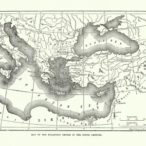
Map / Europe / Balkans C1850
The Turkish-occupied territories in Europe, comprising all the Balkans apart from Greece
Mary Evans Picture Library makes available wonderful images created for people to enjoy over the centuries
Media ID 4342665
© Mary Evans Picture Library 2015 - https://copyrighthub.org/s0/hub1/creation/maryevans/MaryEvansPictureID/10046914
1850 Balkans C1850 Comprising Maps Occupied Territories
12"x10" Modern Frame
Discover the rich history and intrigue of the Balkans region with our exquisite "Map / Europe / Balkans C1850" Framed Print from Media Storehouse. This beautifully preserved antique map, sourced from Mary Evans Prints Online, provides a captivating glimpse into Europe's past, showcasing the Turkish-occupied territories in Europe, including all the Balkans apart from Greece. The intricate details and authenticity of this map are sure to make it a striking addition to any home or office decor. With our high-quality framing options, you can enjoy this piece of history for years to come. Bring a touch of the past into your space with Media Storehouse's Framed Print of "Map / Europe / Balkans C1850."
10x8 Print in an MDF Wooden Frame with 180 gsm Satin Finish Paper. Glazed using shatter proof thin plexi glass. Frame thickness is 1 inch and depth 0.75 inch. Fluted cardboard backing held with clips. Supplied ready to hang with sawtooth hanger and rubber bumpers. Spot clean with a damp cloth. Packaged foam wrapped in a card.
Contemporary Framed and Mounted Prints - Professionally Made and Ready to Hang
Estimated Image Size (if not cropped) is 25.4cm x 25.4cm (10" x 10")
Estimated Product Size is 25.4cm x 30.5cm (10" x 12")
These are individually made so all sizes are approximate
Artwork printed orientated as per the preview above, with landscape (horizontal) or portrait (vertical) orientation to match the source image.
FEATURES IN THESE COLLECTIONS
> Asia
> Turkey
> Related Images
> Europe
> Greece
> Related Images
> Europe
> Related Images
> Historic
> Ancient civilizations
> Ancient Greece
> Greek history
> Maps and Charts
> Early Maps
> Maps and Charts
> Related Images
EDITORS COMMENTS
This vintage map print from Mary Evans Prints Online showcases Europe in the year 1850, specifically focusing on the Balkans region which was predominantly under Turkish occupation at that time. The intricate details of this historical map provide a glimpse into the complex political landscape of the era, with all Balkan territories except Greece being controlled by the Ottoman Empire.
The borders and boundaries depicted on this map offer a visual representation of the power dynamics and territorial divisions that characterized Europe during this period. It serves as a reminder of the turbulent history of the Balkans, marked by centuries of conflict and conquest.
As we study this map, we are transported back in time to an era when empires vied for control over strategic regions like the Balkans. The names of cities and regions evoke images of ancient civilizations and long-forgotten battles that shaped the course of European history.
This print is not just a geographical representation but a window into a world where empires rose and fell, leaving behind legacies that continue to influence modern geopolitics. It is a testament to the enduring importance of understanding our past in order to navigate our present and future with wisdom and insight.
MADE IN THE USA
Safe Shipping with 30 Day Money Back Guarantee
FREE PERSONALISATION*
We are proud to offer a range of customisation features including Personalised Captions, Color Filters and Picture Zoom Tools
SECURE PAYMENTS
We happily accept a wide range of payment options so you can pay for the things you need in the way that is most convenient for you
* Options may vary by product and licensing agreement. Zoomed Pictures can be adjusted in the Cart.