Canvas Print > Historic > Ancient civilizations > Ancient Greece > Greek history
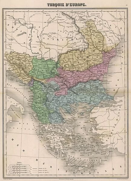
Canvas Print : Map / Europe / Balkans C1850


![]()
Canvas Prints from Mary Evans Picture Library
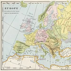
Map / Europe / Balkans C1850
The Turkish-occupied territories in Europe, comprising all the Balkans apart from Greece
Mary Evans Picture Library makes available wonderful images created for people to enjoy over the centuries
Media ID 4342665
© Mary Evans Picture Library 2015 - https://copyrighthub.org/s0/hub1/creation/maryevans/MaryEvansPictureID/10046914
1850 Balkans C1850 Comprising Maps Occupied Territories
20"x16" (51x41cm) Canvas Print
"Enhance your home or office decor with a stunning addition from the Media Storehouse Canvas Prints collection. Featuring the captivating historical map "Map / Europe / Balkans C1850" by Rights Managed from Mary Evans Prints Online, this canvas print showcases Europe's Balkan region during the 19th century, when the Turkish-occupied territories encompassed most of the area, apart from Greece. This high-quality canvas print brings a touch of history and sophistication to any space. With vibrant colors and fine details, this map is sure to be a conversation starter and a beautiful addition to your collection. Order now and bring a piece of the past into your present."
Delivered stretched and ready to hang our premium quality canvas prints are made from a polyester/cotton blend canvas and stretched over a 1.25" (32mm) kiln dried knot free wood stretcher bar. Packaged in a plastic bag and secured to a cardboard insert for safe transit.
Canvas Prints add colour, depth and texture to any space. Professionally Stretched Canvas over a hidden Wooden Box Frame and Ready to Hang
Estimated Product Size is 40.6cm x 50.8cm (16" x 20")
These are individually made so all sizes are approximate
Artwork printed orientated as per the preview above, with portrait (vertical) orientation to match the source image.
FEATURES IN THESE COLLECTIONS
> Asia
> Turkey
> Related Images
> Europe
> Greece
> Related Images
> Europe
> Related Images
> Historic
> Ancient civilizations
> Ancient Greece
> Greek history
> Maps and Charts
> Early Maps
> Maps and Charts
> Related Images
EDITORS COMMENTS
This vintage map print from Mary Evans Prints Online showcases Europe in the year 1850, specifically focusing on the Balkans region which was predominantly under Turkish occupation at that time. The intricate details of this historical map provide a glimpse into the complex political landscape of the era, with all Balkan territories except Greece being controlled by the Ottoman Empire.
The borders and boundaries depicted on this map offer a visual representation of the power dynamics and territorial divisions that characterized Europe during this period. It serves as a reminder of the turbulent history of the Balkans, marked by centuries of conflict and conquest.
As we study this map, we are transported back in time to an era when empires vied for control over strategic regions like the Balkans. The names of cities and regions evoke images of ancient civilizations and long-forgotten battles that shaped the course of European history.
This print is not just a geographical representation but a window into a world where empires rose and fell, leaving behind legacies that continue to influence modern geopolitics. It is a testament to the enduring importance of understanding our past in order to navigate our present and future with wisdom and insight.
MADE IN THE USA
Safe Shipping with 30 Day Money Back Guarantee
FREE PERSONALISATION*
We are proud to offer a range of customisation features including Personalised Captions, Color Filters and Picture Zoom Tools
SECURE PAYMENTS
We happily accept a wide range of payment options so you can pay for the things you need in the way that is most convenient for you
* Options may vary by product and licensing agreement. Zoomed Pictures can be adjusted in the Cart.