Framed Print > Fine Art Storehouse > Map
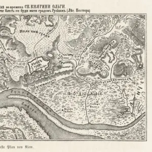
Framed Print : Antique map of Petite Tartarie north of the Black Sea


![]()
Framed Photos from Fine Art Storehouse
Antique map of Petite Tartarie north of the Black Sea
Unleash your creativity and transform your space into a visual masterpiece!
Hemera Technologies
Media ID 13609481
© Getty Images
Black Sea Border Direction Document Geography Georgia Georgia Country Legend Location Place Positioning Scale Ukraine Sea Of Azov
12"x10" Modern Frame
Step back in time with our exquisite Framed Print of the Antique Map of Petite Tartarie North of the Black Sea, available at Media Storehouse. This stunning piece, brought to you by Hemera Technologies from our Fine Art Storehouse, showcases intricate cartographic detail and historical charm. The aged parchment texture and antiqued edges of the map add an authentic touch, while the protective glass and sturdy frame ensure durability. Elevate the decor of any room with this captivating and conversation-starting addition to your collection.
10x8 Print in an MDF Wooden Frame with 180 gsm Satin Finish Paper. Glazed using shatter proof thin plexi glass. Frame thickness is 1 inch and depth 0.75 inch. Fluted cardboard backing held with clips. Supplied ready to hang with sawtooth hanger and rubber bumpers. Spot clean with a damp cloth. Packaged foam wrapped in a card.
Contemporary Framed and Mounted Prints - Professionally Made and Ready to Hang
Estimated Image Size (if not cropped) is 25.4cm x 25.4cm (10" x 10")
Estimated Product Size is 30.5cm x 25.4cm (12" x 10")
These are individually made so all sizes are approximate
Artwork printed orientated as per the preview above, with landscape (horizontal) or portrait (vertical) orientation to match the source image.
FEATURES IN THESE COLLECTIONS
> Fine Art Storehouse
> Map
> Historical Maps
EDITORS COMMENTS
This antique map of Petite Tartarie, located north of the Black Sea, takes us on a journey back in time. Created by Hemera Technologies and preserved as an archival print, this piece showcases the intricate artistry and attention to detail that went into cartography during its era. The map is a testament to the historical significance of this region, providing valuable insights into its geography and borders. With engraved lines demarcating key locations and a legend explaining symbols used, it serves as both a document of the past and a work of art. As we examine this vintage masterpiece, we are transported to an era when physical maps were essential tools for navigation and exploration. The sea of Azov glistens in shades of blue while Georgia's country border stands out prominently against neighboring territories. The scale carefully indicates distances between various places with precision. With no people present within the frame, our focus is solely on the rich history encapsulated within these lines and colors. This photograph captures not just an image but also tells tales from centuries gone by – stories of trade routes traversed, empires risen and fallen, and cultures intermingling along these ancient lands. Whether you are a history enthusiast or simply appreciate fine craftsmanship, this horizontal print invites you to delve into the fascinating world depicted on its surface. It serves as a reminder that even in today's digital age, there is still immense value in preserving tangible artifacts like this antique map for generations to come.
MADE IN THE USA
Safe Shipping with 30 Day Money Back Guarantee
FREE PERSONALISATION*
We are proud to offer a range of customisation features including Personalised Captions, Color Filters and Picture Zoom Tools
SECURE PAYMENTS
We happily accept a wide range of payment options so you can pay for the things you need in the way that is most convenient for you
* Options may vary by product and licensing agreement. Zoomed Pictures can be adjusted in the Cart.