Fine Art Print > Europe > Italy > Veneto > Venice
Fine Art Print : Fra Mauro ( -1460). Fra Mauro map. 1459. Detail
. Fra Mauro map. 1459. Detail")


![]()
Fine Art Prints from Mary Evans Picture Library
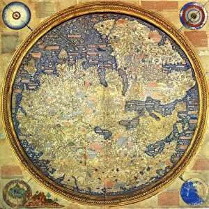
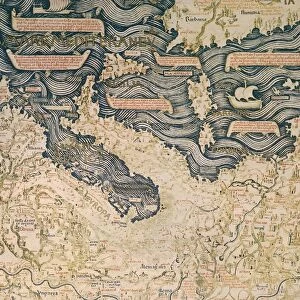
Fra Mauro ( -1460). Fra Mauro map. 1459. Detail
Fra Mauro ( -1460). Fra Mauro map. 1459. Detail of Southeast Asia with the island of Borneo. The map is oriented with south at top. Miniature Painting. ITALY. Venice. Biblioteca nazionale marciana (St. Marks Library)
Mary Evans Picture Library makes available wonderful images created for people to enjoy over the centuries
Media ID 8272683
© Mary Evans Picture Library 2015 - https://copyrighthub.org/s0/hub1/creation/maryevans/MaryEvansPictureID/10685845
Biblioteca Borneo Illuminated Manuscript Manuscripts Marciana Miniatures Nazionale Pacific South East Venice Mauro Oriented
20"x16" (+3" Border) Fine Art Print
Discover the captivating detail of Fra Mauro's 15th-century masterpiece with our Fine Art Prints from Media Storehouse. This exquisite reproduction showcases a detail from Fra Mauro's renowned map of 1459, featuring the island of Borneo in the southeastern region. With intricate depictions of geographical features and vibrant colors, this Miniature Painting from Venice, Italy, offers a glimpse into the rich cartographic history of the world. Bring the beauty and intrigue of this historic map into your home or office with our high-quality Fine Art Prints. Each print is meticulously produced using archival-quality materials to ensure lasting brilliance and vibrancy.
20x16 image printed on 26x22 Fine Art Rag Paper with 3" (76mm) white border. Our Fine Art Prints are printed on 300gsm 100% acid free, PH neutral paper with archival properties. This printing method is used by museums and art collections to exhibit photographs and art reproductions.
Our fine art prints are high-quality prints made using a paper called Photo Rag. This 100% cotton rag fibre paper is known for its exceptional image sharpness, rich colors, and high level of detail, making it a popular choice for professional photographers and artists. Photo rag paper is our clear recommendation for a fine art paper print. If you can afford to spend more on a higher quality paper, then Photo Rag is our clear recommendation for a fine art paper print.
Estimated Image Size (if not cropped) is 50.8cm x 40.6cm (20" x 16")
Estimated Product Size is 66cm x 55.9cm (26" x 22")
These are individually made so all sizes are approximate
Artwork printed orientated as per the preview above, with landscape (horizontal) orientation to match the source image.
FEATURES IN THESE COLLECTIONS
> Asia
> Related Images
> Europe
> Italy
> Related Images
> Europe
> Italy
> Veneto
> Venice
> Maps and Charts
> Italy
> Maps and Charts
> Related Images
EDITORS COMMENTS
Fra Mauro Map: A Glimpse into the 15th Century's Understanding of Southeast Asia and the Island of Borneo This exquisite detail is taken from the Fra Mauro map, a remarkable cartographic masterpiece created by the Venetian friar and cartographer, Fra Mauro, in 1459. The map, housed in the Biblioteca Nazionale Marciana (St. Mark's Library) in Venice, Italy, is a testament to the remarkable progress made in cartography during the Renaissance period. The image showcases a section of Southeast Asia, with the island of Borneo prominently displayed. The map is oriented with the south at the top, a departure from the more common northern hemisphere orientation of maps during this time. This unique orientation may reflect Fra Mauro's access to Eastern sources and his efforts to create a more accurate representation of the region. The map is a miniature painting, meticulously crafted with intricate details and vibrant colors. The depiction of Borneo is particularly noteworthy, as it is one of the most detailed and accurate representations of the island from this era. The map also includes other features of the region, such as the Malay Peninsula, Sumatra, Java, and the Philippines. The Fra Mauro map is considered a significant milestone in the history of cartography, as it represents a substantial improvement over earlier maps in terms of accuracy and detail. Its creation reflects the growing European interest in exploration and the expanding knowledge of the world during the Renaissance period. Today, the map remains an invaluable resource for historians, cartographers, and anyone interested in the history of exploration and the development of cartography.
MADE IN THE USA
Safe Shipping with 30 Day Money Back Guarantee
FREE PERSONALISATION*
We are proud to offer a range of customisation features including Personalised Captions, Color Filters and Picture Zoom Tools
SECURE PAYMENTS
We happily accept a wide range of payment options so you can pay for the things you need in the way that is most convenient for you
* Options may vary by product and licensing agreement. Zoomed Pictures can be adjusted in the Cart.