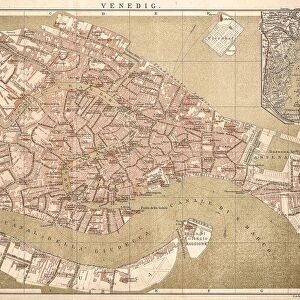
Canvas Print > Europe > Italy > Veneto > Venice
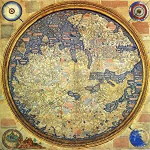
Canvas Print : Fra Mauro ( -1460). Fra Mauro map. 1459. Detail
. Fra Mauro map. 1459. Detail")

. Fra Mauro map. 1459. Detail")


![]()
Canvas Prints from Mary Evans Picture Library
Fra Mauro ( -1460). Fra Mauro map. 1459. Detail
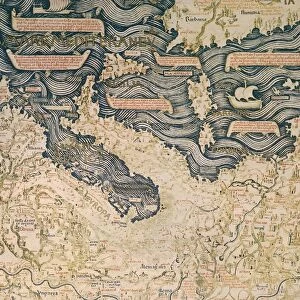
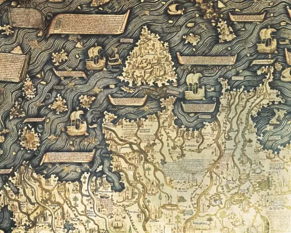
Fra Mauro ( -1460). Fra Mauro map. 1459. Detail of Southeast Asia with the island of Borneo. The map is oriented with south at top. Miniature Painting. ITALY. Venice. Biblioteca nazionale marciana (St. Marks Library)
Mary Evans Picture Library makes available wonderful images created for people to enjoy over the centuries
Media ID 8272683
© Mary Evans Picture Library 2015 - https://copyrighthub.org/s0/hub1/creation/maryevans/MaryEvansPictureID/10685845
Biblioteca Borneo Illuminated Manuscript Manuscripts Marciana Miniatures Nazionale Pacific South East Venice Mauro Oriented
20"x16" (51x41cm) Canvas Print
Introducing the captivating Fra Mauro Map Canvas Print from Media Storehouse, an exquisite addition to your home or office decor. This stunning reproduction showcases a detailed segment of the renowned 1459 Fra Mauro Map, sourced from Mary Evans Prints Online. Originally created by the Venetian cartographer Fra Mauro, this masterpiece is a miniature painting that offers a fascinating glimpse into the geographical knowledge of the mid-15th century. The depicted portion of the map highlights the intriguing Southeast Asian region, with the island of Borneo taking center stage. Bring history to life with this captivating canvas print, which perfectly encapsulates the rich detail and vibrant colors of the original map. Embrace the allure of this ancient cartographic masterpiece and elevate your space with a touch of history and culture. Rights Managed through Mary Evans Prints Online. Origin: ITALY, Venice.
Delivered stretched and ready to hang our premium quality canvas prints are made from a polyester/cotton blend canvas and stretched over a 1.25" (32mm) kiln dried knot free wood stretcher bar. Packaged in a plastic bag and secured to a cardboard insert for safe transit.
Canvas Prints add colour, depth and texture to any space. Professionally Stretched Canvas over a hidden Wooden Box Frame and Ready to Hang
Estimated Product Size is 50.8cm x 40.6cm (20" x 16")
These are individually made so all sizes are approximate
Artwork printed orientated as per the preview above, with landscape (horizontal) orientation to match the source image.
FEATURES IN THESE COLLECTIONS
> Asia
> Related Images
> Europe
> Italy
> Related Images
> Europe
> Italy
> Veneto
> Venice
> Maps and Charts
> Italy
> Maps and Charts
> Related Images
EDITORS COMMENTS
Fra Mauro Map: A Glimpse into the 15th Century's Understanding of Southeast Asia and the Island of Borneo This exquisite detail is taken from the Fra Mauro map, a remarkable cartographic masterpiece created by the Venetian friar and cartographer, Fra Mauro, in 1459. The map, housed in the Biblioteca Nazionale Marciana (St. Mark's Library) in Venice, Italy, is a testament to the remarkable progress made in cartography during the Renaissance period. The image showcases a section of Southeast Asia, with the island of Borneo prominently displayed. The map is oriented with the south at the top, a departure from the more common northern hemisphere orientation of maps during this time. This unique orientation may reflect Fra Mauro's access to Eastern sources and his efforts to create a more accurate representation of the region. The map is a miniature painting, meticulously crafted with intricate details and vibrant colors. The depiction of Borneo is particularly noteworthy, as it is one of the most detailed and accurate representations of the island from this era. The map also includes other features of the region, such as the Malay Peninsula, Sumatra, Java, and the Philippines. The Fra Mauro map is considered a significant milestone in the history of cartography, as it represents a substantial improvement over earlier maps in terms of accuracy and detail. Its creation reflects the growing European interest in exploration and the expanding knowledge of the world during the Renaissance period. Today, the map remains an invaluable resource for historians, cartographers, and anyone interested in the history of exploration and the development of cartography.
MADE IN THE USA
Safe Shipping with 30 Day Money Back Guarantee
FREE PERSONALISATION*
We are proud to offer a range of customisation features including Personalised Captions, Color Filters and Picture Zoom Tools
SECURE PAYMENTS
We happily accept a wide range of payment options so you can pay for the things you need in the way that is most convenient for you
* Options may vary by product and licensing agreement. Zoomed Pictures can be adjusted in the Cart.