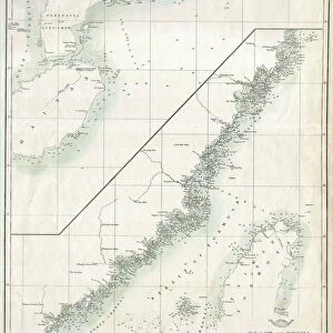
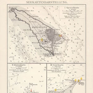
Fine Art Print : 1876, Imray Blue-back Nautical Chart or Map of Taiwan, Formosa, China, topography


![]()
Fine Art Prints from Liszt Collection
1876, Imray Blue-back Nautical Chart or Map of Taiwan, Formosa, China, topography
1876, Imray Blue-back Nautical Chart or Map of Taiwan, Formosa, China
Liszt Collection of nineteenth-century engravings and images to browse and enjoy
Media ID 14006382
© Artokoloro Quint Lox Limited
1876 China Formosa Antique Map Latitude Longitude Mappa Mundi Old Antique Plan Old Antique View Ols Antique Map Rare Old Maps Topo
20"x16" (+3" Border) Fine Art Print
Discover the rich history and intricate detail of the past with our Fine Art Print from Media Storehouse. This captivating piece showcases an 1876 Imray Blue-back Nautical Chart or Map of Taiwan, Formosa, China, from the esteemed Liszt Collection. This vintage chart, with its distinctive blue-backed design, offers a glimpse into the topography of the region as it was known over a century ago. Add an air of nostalgia and maritime charm to your home or office decor with this beautiful and unique Fine Art Print.
20x16 image printed on 26x22 Fine Art Rag Paper with 3" (76mm) white border. Our Fine Art Prints are printed on 300gsm 100% acid free, PH neutral paper with archival properties. This printing method is used by museums and art collections to exhibit photographs and art reproductions.
Our fine art prints are high-quality prints made using a paper called Photo Rag. This 100% cotton rag fibre paper is known for its exceptional image sharpness, rich colors, and high level of detail, making it a popular choice for professional photographers and artists. Photo rag paper is our clear recommendation for a fine art paper print. If you can afford to spend more on a higher quality paper, then Photo Rag is our clear recommendation for a fine art paper print.
Estimated Image Size (if not cropped) is 50.1cm x 40.6cm (19.7" x 16")
Estimated Product Size is 66cm x 55.9cm (26" x 22")
These are individually made so all sizes are approximate
Artwork printed orientated as per the preview above, with landscape (horizontal) orientation to match the source image.
EDITORS COMMENTS
This print showcases a remarkable piece of history - the 1876 Imray Blue-back Nautical Chart or Map of Taiwan, Formosa, China. With its intricate details and stunning topography, this map offers a glimpse into the past, allowing us to explore the geography and cartography of this region from over a century ago. The carefully illustrated landforms and geographic features on this vintage chart transport us back in time, inviting us to embark on a journey of discovery and exploration. The grid lines marking latitude and longitude add an element of precision to this artistic representation of Taiwan's landscape. As we gaze upon this ancient artifact, we are reminded of the importance that maps held in navigation during those times. This decorative piece not only serves as a historical document but also as an art form with its aged paper texture and retro aesthetic. With its rich colors and detailed illustrations, this old antique view takes us back to an era when maps were essential tools for travelers seeking new frontiers. It reminds us how far we have come in our understanding of the world while appreciating the beauty inherent in these rare old maps.
MADE IN THE USA
Safe Shipping with 30 Day Money Back Guarantee
FREE PERSONALISATION*
We are proud to offer a range of customisation features including Personalised Captions, Color Filters and Picture Zoom Tools
SECURE PAYMENTS
We happily accept a wide range of payment options so you can pay for the things you need in the way that is most convenient for you
* Options may vary by product and licensing agreement. Zoomed Pictures can be adjusted in the Cart.