Fine Art Print > Europe > United Kingdom > Scotland > Edinburgh > Edinburgh
Fine Art Print : Map of the Barbary States, 1902. Creator: Unknown


![]()
Fine Art Prints From Heritage Images
Map of the Barbary States, 1902. Creator: Unknown
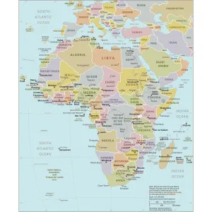
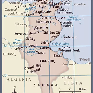
Map of the Barbary States, 1902. Showing Morocco, Algeria, Tunisia, and Libya on the North African coast, with inset of Gibraltar. From The Century Atlas of the World. [John Walker & Co, Ltd. London, 1902]
Heritage Images features heritage image collections
Media ID 15512426
© The Print Collector / Heritage-Images
Algeria Coastline Edinburgh Geographical Institute Libya Mediterranean Sea Morocco North Africa Tunisia Barbary Coast
20"x16" (+3" Border) Fine Art Print
Discover the rich history of North Africa with our exquisite Fine Art Print of the Map of the Barbary States from 1902. This stunning vintage map, sourced from The Century Atlas of the World, showcases the Barbary States of Morocco, Algeria, Tunisia, and Libya, located on the North African coast. With intricate detail and beautiful cartography, this map also features an inset of Gibraltar, making it a must-have for history enthusiasts, collectors, or those seeking to adorn their walls with a piece of the past. Unknown creator, Heritage Images.
20x16 image printed on 26x22 Fine Art Rag Paper with 3" (76mm) white border. Our Fine Art Prints are printed on 300gsm 100% acid free, PH neutral paper with archival properties. This printing method is used by museums and art collections to exhibit photographs and art reproductions.
Our fine art prints are high-quality prints made using a paper called Photo Rag. This 100% cotton rag fibre paper is known for its exceptional image sharpness, rich colors, and high level of detail, making it a popular choice for professional photographers and artists. Photo rag paper is our clear recommendation for a fine art paper print. If you can afford to spend more on a higher quality paper, then Photo Rag is our clear recommendation for a fine art paper print.
Estimated Image Size (if not cropped) is 50.8cm x 35.9cm (20" x 14.1")
Estimated Product Size is 66cm x 55.9cm (26" x 22")
These are individually made so all sizes are approximate
Artwork printed orientated as per the preview above, with landscape (horizontal) orientation to match the source image.
FEATURES IN THESE COLLECTIONS
> Africa
> Algeria
> Related Images
> Africa
> Libya
> Related Images
> Africa
> Morocco
> Related Images
> Africa
> Tunisia
> Related Images
> Europe
> United Kingdom
> Scotland
> Edinburgh
> Edinburgh
> Europe
> United Kingdom
> Scotland
> Lothian
> Edinburgh
EDITORS COMMENTS
This print showcases a Map of the Barbary States, created in 1902 by an unknown artist. The map provides a detailed representation of Morocco, Algeria, Tunisia, and Libya along the North African coast. It also includes an inset of Gibraltar, adding to its historical significance. The vibrant colors used in this print bring life to the continent and highlight the diverse landscapes found within these regions. Created during the early 20th century, this map offers valuable insights into Africa's geographical features and political boundaries at that time. The Edinburgh Geographical Institute is credited for producing this remarkable piece which was featured in The Century Atlas of the World published by John Walker & Co. , Ltd. , London in 1902. Its inclusion in such a prestigious publication further emphasizes its importance as a reliable source for geographic information. Preserved by The Print Collector, this image captures not only the beauty but also serves as a testament to our ever-evolving understanding of global geography. As we explore this map today, it allows us to appreciate how much has changed over time while providing context for historical events that shaped these nations.
MADE IN THE USA
Safe Shipping with 30 Day Money Back Guarantee
FREE PERSONALISATION*
We are proud to offer a range of customisation features including Personalised Captions, Color Filters and Picture Zoom Tools
SECURE PAYMENTS
We happily accept a wide range of payment options so you can pay for the things you need in the way that is most convenient for you
* Options may vary by product and licensing agreement. Zoomed Pictures can be adjusted in the Basket.