Fine Art Print > Europe > Czech Republic > Heritage Sites > Historic Centre of Prague
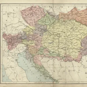
Fine Art Print : Prague map 1896


![]()
Fine Art Prints from Fine Art Storehouse
Prague map 1896
Meyers Konversations-Lexikon
Unleash your creativity and transform your space into a visual masterpiece!
THEPALMER
Media ID 13612367
© Roberto A Sanchez
Bohemia Czech Republic Dictionary European Union Prague Retro Styled
21"x14" (+3" Border) Fine Art Print
Step back in time with our exquisite Prague map print from THEPALMER, available in the Media Storehouse Fine Art Prints collection. This intricately detailed map, originally published in the esteemed Meyers Konversations-Lexikon in 1896, offers a captivating glimpse into the history and architecture of Prague during the late 19th century. The rich, vintage hues and meticulous lines bring the enchanting city to life, making this print an elegant addition to any home or office space. Transport yourself to a bygone era with this stunning work of art.
21x14 image printed on 27x20 Fine Art Rag Paper with 3" (76mm) white border. Our Fine Art Prints are printed on 300gsm 100% acid free, PH neutral paper with archival properties. This printing method is used by museums and art collections to exhibit photographs and art reproductions.
Our fine art prints are high-quality prints made using a paper called Photo Rag. This 100% cotton rag fibre paper is known for its exceptional image sharpness, rich colors, and high level of detail, making it a popular choice for professional photographers and artists. Photo rag paper is our clear recommendation for a fine art paper print. If you can afford to spend more on a higher quality paper, then Photo Rag is our clear recommendation for a fine art paper print.
Estimated Image Size (if not cropped) is 53.3cm x 35.5cm (21" x 14")
Estimated Product Size is 68.6cm x 50.8cm (27" x 20")
These are individually made so all sizes are approximate
Artwork printed orientated as per the preview above, with landscape (horizontal) orientation to match the source image.
FEATURES IN THESE COLLECTIONS
> Europe
> Czech Republic
> Heritage Sites
> Historic Centre of Prague
> Europe
> Czech Republic
> Maps
> Europe
> Czech Republic
> Posters
> Europe
> Czech Republic
> Prague
> Europe
> Czech Republic
> Related Images
> Europe
> Related Images
> Maps and Charts
> Related Images
> Fine Art Storehouse
> The Magical World of Illustration
> Palmer Illustrated Collection
> Fine Art Storehouse
> Map
> Historical Maps
> Fine Art Storehouse
> Top Sellers - Art Prints
EDITORS COMMENTS
This print takes us back in time to the enchanting city of Prague in 1896. A vintage map, sourced from Meyers Konversations-Lexikon, beautifully captures the essence of this European gem. The retro-styled engraving showcases intricate details and a level of craftsmanship that is seldom seen today. As we gaze upon this antique image, we are transported to an era when cartography was both an art form and a scientific endeavor. The carefully etched lines depict the physical geography of Prague with precision, highlighting its position as the capital city of Bohemia within the Czech Republic. The horizontal composition allows us to explore every corner of this historic metropolis. From its charming cobblestone streets to its majestic landmarks, each element on the map tells a story about Prague's rich heritage. Intriguingly, this illustration also serves as a reminder of how cities evolve over time. As part of the European Union now, it is fascinating to see how Prague has transformed since 1896 while still retaining its old-world charm. Whether you are a history enthusiast or simply captivated by beautiful artwork, "Prague Map 1896" offers a glimpse into a bygone era. This stunning piece curated by THEPALMER brings together nostalgia and fascination for those who appreciate fine art prints that transcend time and place.
MADE IN THE USA
Safe Shipping with 30 Day Money Back Guarantee
FREE PERSONALISATION*
We are proud to offer a range of customisation features including Personalised Captions, Color Filters and Picture Zoom Tools
SECURE PAYMENTS
We happily accept a wide range of payment options so you can pay for the things you need in the way that is most convenient for you
* Options may vary by product and licensing agreement. Zoomed Pictures can be adjusted in the Cart.