Fraud Blocker Skip to main content

Home > Europe > Hungary > Maps

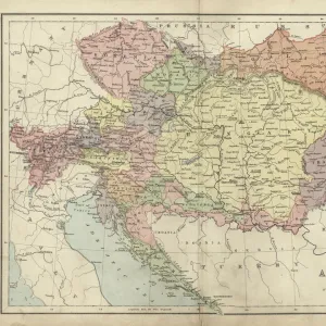
Antique map of Austria Hungary 19th Century

 : Antique map of Austria Hungary 19th Century
Sold 3
In Stock
We accept all major payment options so you can pay for the things you need in the way that is most convenient for you

Choose Your Product


Fine Art Storehouse Photo Prints and Wall Art

Antique map of Austria Hungary 19th Century

Vintage engraving of a Antique damaged map of Austro-Hungarian Empire in the 19th Century, 1873. Unleash your creativity and transform your space into a visual masterpiece. © This content is subject to copyright

duncan1890

Media ID 14756876

Austria Hungary Austrian Empire Austro Hungarian Empire

FEATURES IN THESE COLLECTIONS

> Europe > Austria > Maps

> Europe > Austria > Posters

> Europe > Austria > Related Images

> Europe > Hungary > Maps

> Europe > Hungary > Posters

> Europe > Hungary > Related Images

> Fine Art Storehouse > Map > Historical Maps

> Fine Art Storehouse > Map

> Maps and Charts > Austria

> Maps and Charts > Hungary

> Maps and Charts > Related Images

SECURE PAYMENTS
We accept all major payment options so you can pay for the things you need in the way that is most convenient for you

Made in USA
Safe Shipping, Easy Returns

FREE PERSONALISATION
We are proud to offer a range of customisation including Cropping, Captions, and Filters. Zoom Cropping can be adjusted in the basket


EDITORS COMMENTS

This print showcases an exquisite antique map of Austria Hungary from the 19th century, transporting us back to a time of grandeur and historical significance. The vintage engraving beautifully captures the intricate details of this damaged yet enchanting map, which dates back to 1873. As we gaze upon this piece, we are instantly transported into the heart of the Austro-Hungarian Empire, marveling at its vast territories and diverse landscapes. The delicate lines and faded colors evoke a sense of nostalgia, reminding us of a bygone era filled with imperial splendor. The Austrian Empire's rich history comes alive through this remarkable artwork. It serves as a visual testament to the empire's influence over Central Europe during its peak in the 19th century. From Vienna's elegant architecture to Budapest's majestic bridges spanning across the Danube River, every corner is meticulously depicted on this antique map. Duncan1890 has masterfully captured not just an image but also a story within this photo print. It invites us to explore and appreciate our past while igniting our curiosity about forgotten lands and forgotten times. Whether you are an avid historian or simply captivated by old-world charm, this stunning piece will undoubtedly add character and sophistication to any space it graces. Allow yourself to be transported through time as you immerse yourself in the beauty and intrigue that lies within this Antique Map of Austria Hungary from Fine Art Storehouse.


Framed Prints of Antique map of Austria Hungary 19th Century

Introducing the exquisite "Antique map of Austria Hungary 19th Century" from our Media Storehouse Framed Prints collection. This captivating piece, created by the talented artist duncan1890 from Fine Art Storehouse, is a vintage engraving of an antique damaged map of the Austro-Hungarian Empire in the 1873. The intricate details of the map's aging and the patina of its damage add to its unique charm, transporting you back in time to a bygone era. Each print comes professionally framed, ensuring a beautiful presentation that will make a striking addition to any room in your home or office. Immerse yourself in history and add a touch of vintage elegance to your space with this one-of-a-kind Framed Print.


Photo Prints of Antique map of Austria Hungary 19th Century

Discover the captivating history of the Austro-Hungarian Empire with our vintage engraving of an antique damaged map from the Media Storehouse range. This exquisite photographic print, sourced from Fine Art Storehouse under the artist name duncan1890, showcases an intricately detailed antique map of Austria-Hungary from the 19th century, specifically dated to 1873. The aged patina and subtle damage add to the map's authentic character, transporting you back in time. Bring this captivating piece of history into your home or office as a conversation starter or a reminder of the intricate past of Europe. Order now and add a touch of vintage charm to your space.


Poster Prints of Antique map of Austria Hungary 19th Century

Introducing the captivating Antique map of Austria-Hungary from the Media Storehouse collection, brought to you by the talented artist duncan1890 from Fine Art Storehouse. This exquisite 19th century print showcases a vintage engraving of the Austro-Hungarian Empire in its damaged glory, dating back to 1873. Add an air of historical charm to your space with this intricately detailed and authentically aged map. A perfect addition to any study, office, or living room, this unique piece is sure to spark conversation and inspire curiosity. Experience the rich history of Austria-Hungary through the beauty of this antique map print.


Jigsaw Puzzles of Antique map of Austria Hungary 19th Century

Discover the rich history of the Austro-Hungarian Empire with our Antique Map of Austria Hungary 19th Century jigsaw puzzle from the Media Storehouse collection. This intricately detailed puzzle features an enchanting vintage engraving by duncan1890 from the Fine Art Storehouse. Dating back to 1873, this antique map showcases the damaged borders and historical divisions of the Austro-Hungarian Empire in an authentic and captivating way. Perfect for history buffs, puzzle enthusiasts, or anyone looking to add a touch of vintage charm to their home, this puzzle promises a challenging and rewarding experience. Immerse yourself in the past as you piece together this intricate jigsaw puzzle and bring the history of the Austro-Hungarian Empire to life.

diamond
Made With High Grade Materials
thumb_up
Professional Quality Finish
package_2
Carefully Packed To Aid Safe Arrival

You May Also Like


House of Parliament in Budapest, HungaryHouse of Parliament in Budapest, Hungary
Add to Basket
Olympic 400m race finish 1924, Eric LiddellOlympic 400m race finish 1924, Eric Liddell
Add to Basket
Budapest city mapBudapest city map
Add to Basket
Budapest city map 1895Budapest city map 1895
Add to Basket
Hungary, Budapest, Aerial view of Buda CastleHungary, Budapest, Aerial view of Buda Castle
Add to Basket
View of the Chain Bridge and Skyline of Budapest Along Danube River, HungaryView of the Chain Bridge and Skyline of Budapest Along Danube River, Hungary
Add to Basket
Hungary, Budapest, Castle District, Royal Palace and Chain Bridge over River DanubeHungary, Budapest, Castle District, Royal Palace and Chain Bridge over River Danube
Add to Basket
Antique map of Austrian Empire, 1897, late 19th CenturyAntique map of Austrian Empire, 1897, late 19th Century
Add to Basket
Austria-Hungary and Neighbouring Lands - Map, 1920. Creator: John Bartholomew & SonAustria-Hungary and Neighbouring Lands - Map, 1920. Creator: John Bartholomew & Son
Add to Basket
Europe Map C1914Europe Map C1914
Add to Basket
Map of Central Europe, World War OneMap of Central Europe, World War One
Add to Basket
Map of England in 1066Map of England in 1066
Add to Basket

Gallery Wall Inspiration

Map Of New Holland
Antique map of Britain under the Anglo Saxons
Map of India 1900
Map of Dorset 1883
Antique map of the Roman Empire
Map of Middle East - illustration
New South Wales map 1884
Map of Cyprus, published in 1880
Antquie Map of London, 1880
Map of Anglo-Saxon Kingdoms and the Danelaw, 9th Century
Antique map of Britain under the Ancient Romans
Apostle Pauls Missionary Journeys, lithograph, published in 1886
Earth map according to Herodotus
Sicily map 1895
Battle Of Waterloo
Map of Cyprus
Antique map, Scotland, Jura, Mull, Argyll, Islay 19th Century
Map of Devon 1883
Map of Ireland 1897
Antique map of Tasmania
Ethnological map of the Austro-Hungarian Empire, lithograph, published in 1897
Cornwall map 1884
Antique map of Ireland
Old map of Australia 1899
Antique map of New Zealand in the 19th Century, 1873
Antique map of Hadrians wall
Greece at the beginning of the Peloponnesian War (431-404 BC)

Discover Our Collections


MapMap
View Collection
Austria Related ImagesAustria Related Images
View Collection
Hungary Related ImagesHungary Related Images
View Collection
MapsMaps
View Collection
MapsMaps
View Collection
Maps and Charts Related ImagesMaps and Charts Related Images
View Collection
AustriaAustria
View Collection
HungaryHungary
View Collection
PostersPosters
View Collection
PostersPosters
View Collection
Historical MapsHistorical Maps
View Collection


© Copyright Media Storehouse, All Rights Reserved 2003 - 2025
Facebook     Pinterest     100% Payment Secure     Reviews IO