Fine Art Print > Arts > Artists > S > Christopher Saxton
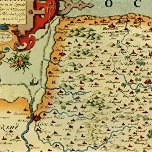
Fine Art Print : A Map of Westmorland and Cumberland, 1576 (hand-coloured engraving)
")

![]()
Fine Art Prints From Fine Art Finder
A Map of Westmorland and Cumberland, 1576 (hand-coloured engraving)
985982 A Map of Westmorland and Cumberland, 1576 (hand-coloured engraving) by Saxton, Christopher (c.1542-c.1610); 38x48.5 cm; Private Collection; (add.info.: A Map of Westmorland and Cumberland; Westmorlandiae et Cumberlandiae Comit: Nova Vera et Elaborata Descriptio. Christopher Saxton (circa 1540-1610). Hand-coloured engraving. Engraved in 1576. 38 x 48.5cm.); Photo eChristies Images; English, out of copyright
Media ID 22202880
© Christie's Images / Bridgeman Images
1576 Armorial Cartographer Coats Of Arms Crest Cumberland Cumbria English Text Geographic Hand Colored Hand Coloring Hand Coloured Hand Colouring Hand Tinted Handcolored Language Lettering Navigational Equipment Prints Profession Westmorland Word Christopher Saxton Natural Space
20"x16" (+3" Border) Fine Art Print
Discover the rich history of England's Lake District with this exquisite Fine Art Print of A Map of Westmorland and Cumberland, 1576. This hand-coloured engraving, created by renowned cartographer Christopher Saxton, provides a fascinating glimpse into the past. The intricate details and vibrant colors bring the landscapes of Westmorland and Cumberland to life, making this a must-have addition to any home or office. With its historical significance and timeless beauty, this Fine Art Print is not just a decorative piece, but a journey through time. Order yours today and bring a piece of history into your space.
20x16 image printed on 26x22 Fine Art Rag Paper with 3" (76mm) white border. Our Fine Art Prints are printed on 300gsm 100% acid free, PH neutral paper with archival properties. This printing method is used by museums and art collections to exhibit photographs and art reproductions.
Our fine art prints are high-quality prints made using a paper called Photo Rag. This 100% cotton rag fibre paper is known for its exceptional image sharpness, rich colors, and high level of detail, making it a popular choice for professional photographers and artists. Photo rag paper is our clear recommendation for a fine art paper print. If you can afford to spend more on a higher quality paper, then Photo Rag is our clear recommendation for a fine art paper print.
Estimated Image Size (if not cropped) is 50.2cm x 40.6cm (19.8" x 16")
Estimated Product Size is 66cm x 55.9cm (26" x 22")
These are individually made so all sizes are approximate
Artwork printed orientated as per the preview above, with landscape (horizontal) orientation to match the source image.
FEATURES IN THESE COLLECTIONS
> Fine Art Finder
> Artists
> Christopher Saxton
> Fine Art Finder
> Artists
> Giovanni Battista Piranesi
> Fine Art Finder
> Temp Classification
> Arts
> Artists
> S
> Christopher Saxton
> Europe
> United Kingdom
> England
> Cumberland
> Europe
> United Kingdom
> England
> Cumbria
> Related Images
> Europe
> United Kingdom
> England
> Maps
> Europe
> United Kingdom
> England
> Westmorland
> Europe
> United Kingdom
> Maps
EDITORS COMMENTS
This hand-coloured engraving, titled "A Map of Westmorland and Cumberland, 1576" takes us back in time to the rich history of cartography. Created by Christopher Saxton around 1576, this meticulously detailed map showcases the counties of Westmorland and Cumberland in England. Measuring at 38x48.5 cm, this print is a true testament to Saxton's skill as a cartographer. The intricate lines and delicate shading bring the landscape to life, while the vibrant colours add an element of enchantment. The map not only provides geographical information but also offers glimpses into the cultural heritage of these regions. Coats of arms are proudly displayed throughout, representing noble families and their ancestral ties to these lands. The English text accompanying the map further enhances our understanding of its significance. As we explore this piece closely, we can almost imagine ourselves navigating through its coastal contours with navigational equipment from that era. It serves as a reminder that maps were once essential tools for exploration and trade. With its meticulous detail and historical context, this hand-coloured engraving transports us back in time to an era when cartographers like Christopher Saxton played a vital role in shaping our understanding of geography. It is truly a treasure worth cherishing for both its artistic beauty and historical value.
MADE IN THE USA
Safe Shipping with 30 Day Money Back Guarantee
FREE PERSONALISATION*
We are proud to offer a range of customisation features including Personalised Captions, Color Filters and Picture Zoom Tools
SECURE PAYMENTS
We happily accept a wide range of payment options so you can pay for the things you need in the way that is most convenient for you
* Options may vary by product and licensing agreement. Zoomed Pictures can be adjusted in the Basket.