Fine Art Print > Arts > Artists > S > Spanish School
Fine Art Print : Claudis Ptolomaeus, 100-170


![]()
Fine Art Prints From Fine Art Finder
Claudis Ptolomaeus, 100-170
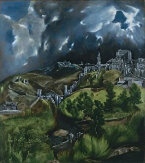
3499627 Claudis Ptolomaeus, 100-170; Biblioteca Universidad, Salamanca, Spain; (add.info.: Claudis Ptolomaeus (100-170). Cosmographia, map of The Hispanias. Manuscript of 1456. XV Century. Library of the University of Salamanca. Castile and Lion, Spain.); PHAS/UIG
Media ID 38153424
© PHAS/UIG / Bridgeman Images
Castile Cosmographia Feline Library Lions Salamanca Tawny Universities University School 1456 Educating
20"x16" (+3" Border) Fine Art Print
Discover the timeless beauty of historical maps with our Fine Art Prints collection featuring "Claudis Ptolomaeus, 100-170" by Bridgeman Images. Transport yourself to ancient Spain with this stunning piece from Fine Art Finder's archives.
20x16 image printed on 26x22 Fine Art Rag Paper with 3" (76mm) white border. Our Fine Art Prints are printed on 300gsm 100% acid free, PH neutral paper with archival properties. This printing method is used by museums and art collections to exhibit photographs and art reproductions.
Our fine art prints are high-quality prints made using a paper called Photo Rag. This 100% cotton rag fibre paper is known for its exceptional image sharpness, rich colors, and high level of detail, making it a popular choice for professional photographers and artists. Photo rag paper is our clear recommendation for a fine art paper print. If you can afford to spend more on a higher quality paper, then Photo Rag is our clear recommendation for a fine art paper print.
Estimated Image Size (if not cropped) is 49.9cm x 40.6cm (19.6" x 16")
Estimated Product Size is 66cm x 55.9cm (26" x 22")
These are individually made so all sizes are approximate
Artwork printed orientated as per the preview above, with landscape (horizontal) orientation to match the source image.
FEATURES IN THESE COLLECTIONS
> Fine Art Finder
> Artists
> El (1541-1614) Greco
> Arts
> Artists
> S
> Spanish School
> Maps and Charts
> Related Images
> Maps and Charts
> Spain
EDITORS COMMENTS
This print captures the intricate map of The Hispanias, created by the renowned Claudis Ptolomaeus in 1456. Ptolemy, as he is commonly known, was a Greek mathematician, astronomer, and geographer whose work laid the foundation for modern cartography.
The manuscript displayed in this image showcases Ptolemy's meticulous attention to detail and his advanced understanding of geography during the XV century. The map depicts the regions of Castile and Leon in Spain with remarkable accuracy for its time.
Located in the Library of the University of Salamanca, this rare manuscript is a testament to both Ptolemy's genius and the enduring legacy of educational institutions like universities. The presence of lions on either side of the map adds an element of regality and symbolism to this historical artifact.
As we gaze upon this print, we are reminded not only of Ptolemy's contributions to our understanding of the world but also of the importance of preserving knowledge through manuscripts like these. It serves as a reminder that education has always been at the heart of human progress and that libraries continue to be invaluable repositories for our collective wisdom.
MADE IN THE USA
Safe Shipping with 30 Day Money Back Guarantee
FREE PERSONALISATION*
We are proud to offer a range of customisation features including Personalised Captions, Color Filters and Picture Zoom Tools
SECURE PAYMENTS
We happily accept a wide range of payment options so you can pay for the things you need in the way that is most convenient for you
* Options may vary by product and licensing agreement. Zoomed Pictures can be adjusted in the Basket.