Home > Africa > Guinea > Maps
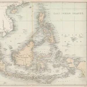
Map of South-Eastern Asia and Northern Australia (colour litho)
")
![]()
Wall Art and Photo Gifts from Fine Art Finder
Map of South-Eastern Asia and Northern Australia (colour litho)
726783 Map of South-Eastern Asia and Northern Australia (colour litho) by English School, (19th century); Private Collection; (add.info.: Map of South-Eastern Asia and Northern Australia, showing the districts in Annam and Tonquin which France proposes to annex and to place under a Protectorate. The portion of New Guinea propsed to be acquired by Queensland. And the districts affected by the Volcanic Eruptions in Java. With an enlarged map of Tonquin, Annam and Cochin China, showing the Districts which France proposes to Annex and to place under a Protectorate. Published in a supplement to The Graphic, 22 September 1883.); © Look and Learn
Media ID 23017954
© Look and Learn / Bridgeman Images
Cartography Territory The Graphic Northern Australia
FEATURES IN THESE COLLECTIONS
> Asia
> Related Images
> Europe
> Related Images
> Fine Art Finder
> Artists
> English School
> Fine Art Finder
> Artists
> Sydney Prior (after) Hall
> Fine Art Finder
> Temp Classification
> Maps and Charts
> Related Images
EDITORS COMMENTS
This print showcases a vibrant "Map of South-Eastern Asia and Northern Australia" created by the English School in the 19th century. The map, part of a private collection, offers an intriguing glimpse into the historical cartography of this region. The detailed illustration reveals various districts in Annam and Tonquin that France proposed to annex and place under its protectorate during that time. Additionally, it highlights Queensland's interest in acquiring a portion of New Guinea. Furthermore, the map provides insights into the impact of volcanic eruptions in Java through markings indicating affected districts. Accompanying this comprehensive depiction is an enlarged map specifically focusing on Tonquin, Annam, and Cochin China - regions targeted for French annexation and protection. Published as a supplement to The Graphic on September 22nd, 1883, this artwork captures both geographical information and political aspirations prevalent during that era. The image also serves as a reminder of Europe's colonial ambitions at the time with France seeking to expand its territories overseas. It reflects not only European influence but also sheds light on French culture within these regions. Brought to you by Bridgeman Images' Fine Art Finder collection, this print preserves an important piece of history while offering viewers an opportunity to explore the intricate details embedded within this remarkable map from centuries past.
MADE IN THE USA
Safe Shipping with 30 Day Money Back Guarantee
FREE PERSONALISATION*
We are proud to offer a range of customisation features including Personalised Captions, Color Filters and Picture Zoom Tools
SECURE PAYMENTS
We happily accept a wide range of payment options so you can pay for the things you need in the way that is most convenient for you
* Options may vary by product and licensing agreement. Zoomed Pictures can be adjusted in the Cart.