Home > Europe > Poland > Maps
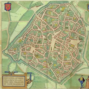
Map of Zamosc, from Civitates Orbis Terrarum by Georg Braun (1541-1622

![]()
Wall Art and Photo Gifts from Fine Art Finder
Map of Zamosc, from Civitates Orbis Terrarum by Georg Braun (1541-1622
STC138958 Map of Zamosc, from Civitates Orbis Terrarum by Georg Braun (1541-1622) and Frans Hogenberg (1535-90) c.1572-1617 (coloured engraving) by Hoefnagel, Joris (1542-1600) (after); Private Collection; The Stapleton Collection; Flemish, out of copyright
Media ID 23255674
© The Stapleton Collection / Bridgeman Images
Atlas Birds Eye View Cities Of The World Fortification Fortified Wall Poland Polish
FEATURES IN THESE COLLECTIONS
> Arts
> Artists
> H
> Joris Hoefnagel
> Europe
> Poland
> Related Images
> Fine Art Finder
> Artists
> Joris (after) Hoefnagel
> Fine Art Finder
> Maps (celestial & Terrestrial)
> Maps and Charts
> Related Images
> Maps and Charts
> World
EDITORS COMMENTS
This print showcases a remarkable piece of cartographic history - the Map of Zamosc, from Civitates Orbis Terrarum by Georg Braun and Frans Hogenberg. Created between 1572 and 1617, this coloured engraving provides a birds-eye view of the city's fortified wall and fortification. The intricate details captured in this map transport us back to a time when Poland was at its zenith. The city of Zamosc, with its strategic location, emerges as an architectural marvel surrounded by lush landscapes. Every street, building, and alley is meticulously depicted, offering a glimpse into the past. As we explore this historical gem through Joris Hoefnagel's skilled craftsmanship, it becomes apparent that this map served not only as a navigational tool but also as an artistic masterpiece. The vibrant colours breathe life into the streets while simultaneously highlighting the grandeur of Zamosc's architecture. Beyond its aesthetic appeal lies an invaluable resource for historians and geographers alike. This engraving serves as a testament to human ingenuity in capturing our world on paper during an era when satellite imagery was unimaginable. Preserved within private collections like The Stapleton Collection today, these ancient maps continue to inspire awe and curiosity about our collective heritage. Let us cherish such treasures that bridge the gap between past and present while celebrating their enduring beauty for generations to come.
MADE IN THE USA
Safe Shipping with 30 Day Money Back Guarantee
FREE PERSONALISATION*
We are proud to offer a range of customisation features including Personalised Captions, Color Filters and Picture Zoom Tools
SECURE PAYMENTS
We happily accept a wide range of payment options so you can pay for the things you need in the way that is most convenient for you
* Options may vary by product and licensing agreement. Zoomed Pictures can be adjusted in the Cart.