Home > Animals > Mammals > Cats (Wild) > Populator
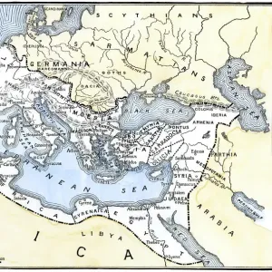
Geographic map of the Mediterranean Sea and the Black Sea showing the coasts of Europe (France, Spain, Italy and Africa (Tunisia, Algeria, Egypt). The sea is populated with monsters and caravels
. The sea is populated with monsters and caravels")
![]()
Wall Art and Photo Gifts from Fine Art Finder
Geographic map of the Mediterranean Sea and the Black Sea showing the coasts of Europe (France, Spain, Italy and Africa (Tunisia, Algeria, Egypt). The sea is populated with monsters and caravels
JLJ4592326 Geographic map of the Mediterranean Sea and the Black Sea showing the coasts of Europe (France, Spain, Italy and Africa (Tunisia, Algeria, Egypt). The sea is populated with monsters and caravels, while on the land are visible all kinds of animals and inhabitants of the regions). Each country is marked by its coat of arms. Map of Francois Ollive, 1646. Paris, Musee de la Marine by Ollive, Francois (active 1646-1662); Musee de la Marine, Paris, France; (add.info.: Geographic map of the Mediterranean Sea and the Black Sea showing the coasts of Europe (France, Spain, Italy and Africa (Tunisia, Algeria, Egypt). The sea is populated with monsters and caravels, while on the land are visible all kinds of animals and inhabitants of the regions). Each country is marked by its coat of arms. Map of Francois Ollive, 1646. Paris, Musee de la Marine); Photo © Photo Josse
Media ID 25184364
© Josse / Bridgeman Images
Blazon Coat Of Arm Geographical Map Maghrebin Maghrebine Mediterranean Sea 17 17th 17th 17th Xvii 18th Century Afica Afric Central Africa Circa 1600 Early 17th Century Early Xvii Century Maghreb Seventeeth Century
FEATURES IN THESE COLLECTIONS
> Africa
> Algeria
> Related Images
> Africa
> Egypt
> Related Images
> Africa
> Related Images
> Africa
> Tunisia
> Related Images
> Animals
> Mammals
> Cats (Wild)
> Populator
> Europe
> France
> Canton
> Landes
> Fine Art Finder
> Artists
> Francois Ollive
> Fine Art Finder
> Artists
> Guido da Vigevano da Pavia
EDITORS COMMENTS
This print showcases a historic geographic map of the Mediterranean Sea and the Black Sea, created by Francois Ollive in 1646. The map beautifully depicts the coasts of Europe, including France, Spain, Italy, as well as Africa with Tunisia, Algeria, and Egypt. What makes this map truly fascinating is its imaginative portrayal of the sea and land. In the vast expanse of water, we see an array of mythical monsters alongside caravels sailing through these treacherous waters. These fantastical creatures add an element of mystery to the otherwise familiar geography. On land, every region comes to life with various animals and inhabitants depicted in intricate detail. To distinguish each country on this remarkable map, their respective coat of arms is proudly displayed. This attention to detail not only adds visual interest but also provides historical context for understanding political boundaries during that era. Preserved at Musee de la Marine in Paris today, this artwork serves as a testament to Ollive's skillful cartography and his ability to blend reality with imagination. Through this photograph taken by Photo Josse from Fine Art Finder (not mentioning commercial use), we are able to appreciate both the artistry behind this ancient map and gain insight into how people perceived their world centuries ago.
MADE IN THE USA
Safe Shipping with 30 Day Money Back Guarantee
FREE PERSONALISATION*
We are proud to offer a range of customisation features including Personalised Captions, Color Filters and Picture Zoom Tools
SECURE PAYMENTS
We happily accept a wide range of payment options so you can pay for the things you need in the way that is most convenient for you
* Options may vary by product and licensing agreement. Zoomed Pictures can be adjusted in the Cart.