Home > Maps and Charts > British Empire Maps
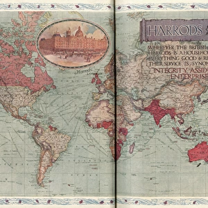
Map of British possessions in 1914 at the outbreak of WWI

![]()
Wall Art and Photo Gifts from Fine Art Finder
Map of British possessions in 1914 at the outbreak of WWI
3614250 Map of British possessions in 1914 at the outbreak of WWI, from The British Empire Universities Modern English Illustrated Dictionary, pub.1914 by English School, (20th century); (add.info.: Map of British possessions in 1914 at the outbreak of WWI. From The British Empire Universities Modern English Illustrated Dictionary, published 1914.); English, out of copyright
Media ID 22734386
© Bridgeman Images
1914 Archival Archive Countries Geographical Outbreak Possessions Territories 1914 1918 1914 1918 Wwi Ww One First World War 1914 1918
FEATURES IN THESE COLLECTIONS
> Arts
> Artists
> Related Images
> Fine Art Finder
> Artists
> English School
> Historic
> World War I and II
> World War I
> Maps and Charts
> British Empire Maps
> Maps and Charts
> Early Maps
> Maps and Charts
> Related Images
> Maps and Charts
> World
EDITORS COMMENTS
This print showcases a Map of British possessions in 1914, capturing the world at the outbreak of World War I. Published in The British Empire Universities Modern English Illustrated Dictionary in 1914, this historical artifact provides us with a glimpse into the vast and influential empire that Britain once possessed. The map depicts an extensive network of countries and territories under British control during the early 20th century. It serves as a testament to the great power that Britain held on a global scale, spanning continents and oceans alike. Each intricate detail engraved on this archival piece invites us to explore the geography and history behind these possessions. As we delve deeper into its illustration, we are reminded of the significance of this era - a time when tensions were brewing across nations, ultimately leading to one of humanity's most devastating conflicts: World War I. This map becomes more than just lines and colors; it represents an epochal turning point for our world. Preserved through time, this engraving by Ken Welsh allows us to reflect upon our shared past while contemplating how it has shaped our present-day geopolitical landscape. Whether viewed from an academic or historical perspective, this image is sure to captivate anyone interested in exploring the intricacies of war, geography, and colonial legacies.
MADE IN THE USA
Safe Shipping with 30 Day Money Back Guarantee
FREE PERSONALISATION*
We are proud to offer a range of customisation features including Personalised Captions, Color Filters and Picture Zoom Tools
SECURE PAYMENTS
We happily accept a wide range of payment options so you can pay for the things you need in the way that is most convenient for you
* Options may vary by product and licensing agreement. Zoomed Pictures can be adjusted in the Cart.