Home > Arts > Artists > C > Abraham Cresques
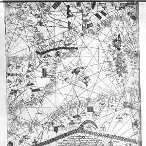
Catalan Atlas, Sheet 7 and 8, 1375 (pen with coloured inks on parchment)
")
![]()
Wall Art and Photo Gifts from Fine Art Finder
Catalan Atlas, Sheet 7 and 8, 1375 (pen with coloured inks on parchment)
5054639 Catalan Atlas, Sheet 7 and 8, 1375 (pen with coloured inks on parchment) by Cresques, Abraham (1325-87); Bibliotheque Nationale, Paris, France; (add.info.: World map made in Majorca, with Jerusalem close to the centre, attributed to the Jewish cartographer Abraham Cresques in the service of the king of Aragon. One of the few surviving examples of medieval cartography, richly illustrated and covers an area from the Atlantic to China, from Scandinavia to the Rio Oro in Africa in six parchment-covered wooden panels.); Spanish, out of copyright
Media ID 22829826
© Bridgeman Images
Atlas Cartography Catalan Catalan Atlas Catalonia Compass Compass Lines Cosmography Early Map Elephant Hydrography Jerusalem Majorcan Mappa Mundi Mediterranean Nautical Nautical Charts Navigation Navigational Portolan Red Sea Sea Chart Sicily Silk Road Spice Trade Spices Vellum World Map
FEATURES IN THESE COLLECTIONS
> Africa
> Related Images
> Animals
> Mammals
> African Elephant
> Animals
> Mammals
> Elephantidae
> African Elephant
> Arts
> Art Movements
> Medieval Art
> Arts
> Artists
> C
> Abraham Cresques
> Arts
> Artists
> O
> Oceanic Oceanic
> Asia
> China
> China Heritage Sites
> Silk Roads: the Routes Network of
> Asia
> Turkey
> Related Images
> Fine Art Finder
> Artists
> Abraham Cresques
> Fine Art Finder
> Artists
> English School
EDITORS COMMENTS
This print showcases the Catalan Atlas, Sheet 7 and 8, a remarkable piece of medieval cartography created in 1375 by Abraham Cresques. Crafted with pen and colored inks on parchment, this world map was made in Majorca under the patronage of the king of Aragon. Now housed at Bibliotheque Nationale in Paris, France, it is one of the few surviving examples from that era. The Catalan Atlas covers an extensive area from Scandinavia to China and from the Atlantic to Africa's Rio Oro. Its rich illustrations depict various regions along with Jerusalem positioned near the center. This masterpiece provides invaluable insights into early navigation, trade routes such as the Silk Road, and geographical knowledge during the 14th century. With its meticulous attention to detail and hydrography, this nautical chart offers a glimpse into maritime exploration during that time period. The use of compass lines highlights its navigational significance while also showcasing major ports along coastlines worldwide. Noteworthy elements within this artwork include depictions of elephants symbolizing Africa's exotic nature and references to Sicily, Greece, Turkey, and other significant locations throughout Europe and Asia. The Catalan Atlas serves as both a testament to Cresques' skill as a Jewish cartographer and an important historical artifact shedding light on medieval cosmography. Its intricate design invites viewers on a journey through time while marveling at humanity's quest for discovery across vast oceans.
MADE IN THE USA
Safe Shipping with 30 Day Money Back Guarantee
FREE PERSONALISATION*
We are proud to offer a range of customisation features including Personalised Captions, Color Filters and Picture Zoom Tools
SECURE PAYMENTS
We happily accept a wide range of payment options so you can pay for the things you need in the way that is most convenient for you
* Options may vary by product and licensing agreement. Zoomed Pictures can be adjusted in the Cart.