Home > Arts > Artists > C > Abraham Cresques
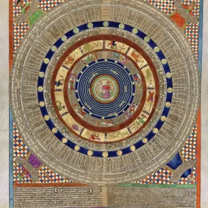
Catalan Atlas, Sheet 11, 1375 (pen with coloured inks on parchment)
")
![]()
Wall Art and Photo Gifts from Fine Art Finder
Catalan Atlas, Sheet 11, 1375 (pen with coloured inks on parchment)
5054644 Catalan Atlas, Sheet 11, 1375 (pen with coloured inks on parchment) by Cresques, Abraham (1325-87); Bibliotheque Nationale, Paris, France; (add.info.: World map made in Majorca, with Jerusalem close to the centre, attributed to the Jewish cartographer Abraham Cresques in the service of the king of Aragon. One of the few surviving examples of medieval cartography, richly illustrated and covers an area from the Atlantic to China, from Scandinavia to the Rio Oro in Africa in six parchment-covered wooden panels.); Spanish, out of copyright
Media ID 23573882
© Bridgeman Images
Atlas Catalan Catalan Atlas Catalonia Compass Compass Lines Cosmography Early Map Hydrography Majorcan Mappa Mundi Nautical Nautical Charts Navigation Navigational Portolan Sea Chart Silk Road Silk Route Spice Trade Spices Travellers Vellum World Map
FEATURES IN THESE COLLECTIONS
> Africa
> Related Images
> Arts
> Art Movements
> Medieval Art
> Arts
> Artists
> C
> Abraham Cresques
> Arts
> Artists
> O
> Oceanic Oceanic
> Asia
> China
> China Heritage Sites
> Silk Roads: the Routes Network of
> Asia
> India
> Related Images
> Fine Art Finder
> Artists
> Abraham Cresques
> Fine Art Finder
> Artists
> English School
EDITORS COMMENTS
This print showcases the Catalan Atlas, Sheet 11, created in 1375 by the skilled Jewish cartographer Abraham Cresques. Housed in the Bibliotheque Nationale in Paris, France, this remarkable world map was crafted on parchment using pen and colored inks. The Catalan Atlas is a rare surviving example of medieval cartography and offers a richly illustrated depiction of the known world at that time. Spanning from Scandinavia to China and from the Atlantic to Africa's Rio Oro, it covers an extensive area across six wooden panels covered with parchment. What sets this map apart is its unique positioning of Jerusalem near the center, reflecting its significance as a holy city. The atlas also provides valuable insights into early maritime exploration and trade routes during the 14th century. With intricate details and meticulous craftsmanship, this masterpiece reveals important information about nautical charts, geography, commerce, navigation tools like compasses and portolans (compass lines), as well as major trading routes such as the Silk Road. The Catalan Atlas serves not only as a navigational aid but also as a testament to cultural exchange between different regions during this era. Its illustrations depict mountains, coastlines, cities along trade routes like India and Asia's Silk Route—offering invaluable knowledge for travelers seeking new lands or merchants looking to expand their spice trade. Overall, this print captures an extraordinary piece of history that continues to fascinate scholars interested in medieval cartography and exploration.
MADE IN THE USA
Safe Shipping with 30 Day Money Back Guarantee
FREE PERSONALISATION*
We are proud to offer a range of customisation features including Personalised Captions, Color Filters and Picture Zoom Tools
SECURE PAYMENTS
We happily accept a wide range of payment options so you can pay for the things you need in the way that is most convenient for you
* Options may vary by product and licensing agreement. Zoomed Pictures can be adjusted in the Cart.